
Topografische Karte Arcadia
Interaktive Karte
Klicken Sie auf die Karte, um die Höhe anzuzeigen.
Arcadia
Arcadia is located slightly northwest of the center of DeSoto County at 27°13'N 81°52'W (27.2176, –81.8599). The Peace River flows past the west side of the city on its way southwest to tidewater at Punta Gorda. Most of Arcadia is more than 40 feet (12 m) above sea level and portions of Arcadia near the center of the city are as high as 65 feet (20 m) above sea level, giving Arcadia one of the highest elevations for a city in Florida.
Über diese Karte
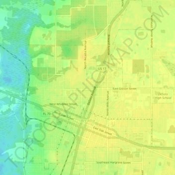
Name: Topografische Karte Arcadia, Höhe, Relief.
Ort: Arcadia, DeSoto County, Florida, United States (27.20230 -81.87990 27.24557 -81.83451)
Durchschnittliche Höhe: 17 m
Minimale Höhe: 2 m
Maximale Höhe: 24 m
Andere topografische Karten
Klicken Sie auf eine Karte, um ihre Topografie, ihre Höhe und ihr Relief anzuzeigen.
Southfort
United States > Florida > DeSoto County
It is located at 27°04′05″N 81°57′50″W / 27.068°N 81.964°W / 27.068; -81.964, its elevation 26 feet (7.9 m).
Durchschnittliche Höhe: 9 m
Hull
United States > Florida > DeSoto County > Hull
Hull is located at 27°07′08″N 81°56′31″W / 27.119°N 81.942°W / 27.119; -81.942, with an elevation of 39 feet (12 m).
Durchschnittliche Höhe: 10 m