
Spenden
Rüsten Sie sich für Ihr nächstes Abenteuer:
Als Amazon-Partner verdient diese Website an qualifizierten Käufen, ohne dass Ihnen zusätzliche Kosten entstehen.
Topografische Karte Annur
Klicken Sie auf die Karte, um die Höhe anzuzeigen.
Spenden
Rüsten Sie sich für Ihr nächstes Abenteuer:
Als Amazon-Partner verdient diese Website an qualifizierten Käufen, ohne dass Ihnen zusätzliche Kosten entstehen.
Annur
Annur is located at 11°14′N 77°08′E / 11.23°N 77.13°E / 11.23; 77.13. It has an average elevation of 338 metres (1108 feet). Annur is well connected by roads including the National Highway 209 (New NH948) (Coimbatore to Bangalore highway) and the State Highway 80 SH80 Avanashi to Mettupalayam passes through Annur.
Spenden
Rüsten Sie sich für Ihr nächstes Abenteuer:
Als Amazon-Partner verdient diese Website an qualifizierten Käufen, ohne dass Ihnen zusätzliche Kosten entstehen.
Über diese Karte
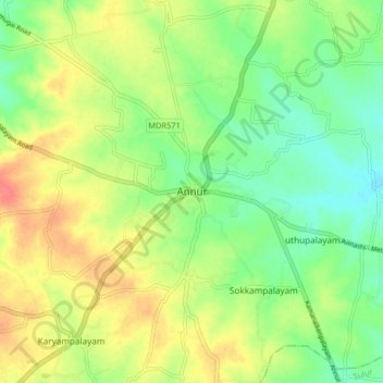
Name: Topografische Karte Annur, Höhe, Relief.
Ort: Annur, Coimbatore North, Coimbatore, Tamil Nadu, 641653, India (11.19297 77.06352 11.27297 77.14352)
Durchschnittliche Höhe: 381 m
Minimale Höhe: 356 m
Maximale Höhe: 412 m
Spenden
Rüsten Sie sich für Ihr nächstes Abenteuer:
Als Amazon-Partner verdient diese Website an qualifizierten Käufen, ohne dass Ihnen zusätzliche Kosten entstehen.
Andere topografische Karten
Klicken Sie auf eine Karte, um ihre Topografie, ihre Höhe und ihr Relief anzuzeigen.