
Topografische Karte Bassins à flot
Interaktive Karte
Klicken Sie auf die Karte, um die Höhe anzuzeigen.
Über diese Karte
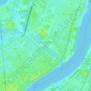
Name: Topografische Karte Bassins à flot, Höhe, Relief.
Durchschnittliche Höhe: 5 m
Minimale Höhe: -4 m
Maximale Höhe: 13 m
Andere topografische Karten
Klicken Sie auf eine Karte, um ihre Topografie, ihre Höhe und ihr Relief anzuzeigen.
Chartrons - Grand Parc - Jardin Public
France > Nouvelle-Aquitaine > Bordeaux
Chartrons - Grand Parc - Jardin Public, Bordeaux, Gironde, Nouvelle-Aquitaine, France métropolitaine, 33000, France
Durchschnittliche Höhe: 9 m
Nansouty - Saint-Genès
France > Nouvelle-Aquitaine > Bordeaux
Nansouty - Saint-Genès, Bordeaux, Gironde, Nouvelle-Aquitaine, France métropolitaine, 33000, France
Durchschnittliche Höhe: 16 m
La Bastide
France > Nouvelle-Aquitaine > Bordeaux
La Bastide, Bordeaux, Nouvelle-Aquitaine, France métropolitaine, 33100, France
Durchschnittliche Höhe: 12 m
Saint-Augustin - Tauzin - Alphonse Dupeux
France > Nouvelle-Aquitaine > Bordeaux
Saint-Augustin - Tauzin - Alphonse Dupeux, Bordeaux, Gironde, Nouvelle-Aquitaine, France métropolitaine, 33000, France
Durchschnittliche Höhe: 19 m
Centre ville
France > Nouvelle-Aquitaine > Bordeaux
Centre ville, Bordeaux, Gironde, Nouvelle-Aquitaine, France métropolitaine, 33000, France
Durchschnittliche Höhe: 14 m