
Topografische Karte Arches National Park
Interaktive Karte
Klicken Sie auf die Karte, um die Höhe anzuzeigen.
Über diese Karte
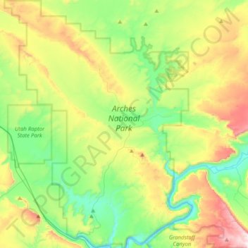
Name: Topografische Karte Arches National Park, Höhe, Relief.
Ort: Arches National Park, Grand County, Utah, United States (38.60474 -109.71320 38.84693 -109.47771)
Durchschnittliche Höhe: 1.476 m
Minimale Höhe: 1.206 m
Maximale Höhe: 1.995 m
The park consists of 310.31 square kilometres (76,680 acres; 119.81 sq mi; 31,031 ha) of high desert located on the Colorado Plateau. The highest elevation in the park is 5,653 feet (1,723 m) at Elephant Butte, and the lowest elevation is 4,085 feet (1,245 m) at the visitor center. The park receives an average of less than 10 inches (250 mm) of rain annually.
Andere topografische Karten
Klicken Sie auf eine Karte, um ihre Topografie, ihre Höhe und ihr Relief anzuzeigen.
Moab
United States > Utah > Grand County
Moab, Grand County, Utah, 84532, United States
Durchschnittliche Höhe: 1.357 m
Manns Peak
United States > Utah > Grand County
Manns Peak, Grand County, Utah, United States
Durchschnittliche Höhe: 3.427 m
Castle Valley
United States > Utah > Grand County
Castle Valley, Grand County, Utah, United States
Durchschnittliche Höhe: 1.610 m
Castleton Tower
United States > Utah > Grand County
Castleton Tower, Grand County, Utah, United States
Durchschnittliche Höhe: 1.549 m