
Topografische Karte McLoud
Interaktive Karte
Klicken Sie auf die Karte, um die Höhe anzuzeigen.
Über diese Karte
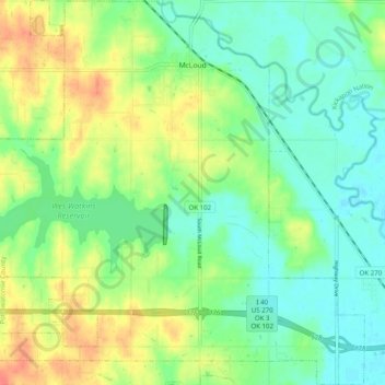
Name: Topografische Karte McLoud, Höhe, Relief.
Ort: McLoud, Pottawatomie County, Oklahoma, 74851, United States (35.36882 -97.14212 35.44941 -97.04716)
Durchschnittliche Höhe: 332 m
Minimale Höhe: 312 m
Maximale Höhe: 367 m
Andere topografische Karten
Klicken Sie auf eine Karte, um ihre Topografie, ihre Höhe und ihr Relief anzuzeigen.
Maud
United States > Oklahoma > Pottawatomie County
Maud, Pottawatomie County, Oklahoma, United States
Durchschnittliche Höhe: 287 m
Saint Louis
United States > Oklahoma > Pottawatomie County
Saint Louis, Pottawatomie County, Oklahoma, 74866, United States
Durchschnittliche Höhe: 285 m
Harjo
United States > Oklahoma > Pottawatomie County
Harjo, Pottawatomie County, Oklahoma, United States
Durchschnittliche Höhe: 284 m
Wanette
United States > Oklahoma > Pottawatomie County
Wanette, Pottawatomie County, Oklahoma, United States
Durchschnittliche Höhe: 309 m
Tribbey
United States > Oklahoma > Pottawatomie County
Tribbey, Pottawatomie County, Oklahoma, United States
Durchschnittliche Höhe: 327 m
Macomb
United States > Oklahoma > Pottawatomie County
Macomb, Pottawatomie County, Oklahoma, United States
Durchschnittliche Höhe: 294 m
Johnson
United States > Oklahoma > Pottawatomie County
Johnson, Pottawatomie County, Oklahoma, United States
Durchschnittliche Höhe: 311 m
Asher
United States > Oklahoma > Pottawatomie County
Asher, Pottawatomie County, Oklahoma, 74826, United States
Durchschnittliche Höhe: 309 m
Trousdale
United States > Oklahoma > Pottawatomie County
Trousdale, Pottawatomie County, Oklahoma, United States
Durchschnittliche Höhe: 304 m
Earlsboro
United States > Oklahoma > Pottawatomie County
Earlsboro, Pottawatomie County, Oklahoma, 74840, United States
Durchschnittliche Höhe: 310 m
Brooksville
United States > Oklahoma > Pottawatomie County
Brooksville, Pottawatomie County, Oklahoma, United States
Durchschnittliche Höhe: 304 m
Centerview
United States > Oklahoma > Pottawatomie County
Centerview, Pottawatomie County, Oklahoma, United States
Durchschnittliche Höhe: 293 m
Macomb
United States > Oklahoma > Pottawatomie County > Macomb
Macomb, Pottawatomie County, Oklahoma, 74852, United States
Durchschnittliche Höhe: 298 m
Shawnee
United States > Oklahoma > Pottawatomie County
Shawnee, Pottawatomie County, Oklahoma, United States
Durchschnittliche Höhe: 316 m
Tecumseh
United States > Oklahoma > Pottawatomie County
Tecumseh, Pottawatomie County, Oklahoma, 74873, United States
Durchschnittliche Höhe: 321 m
Pink
United States > Oklahoma > Pottawatomie County > Pink
Pink, Pottawatomie County, Oklahoma, United States
Durchschnittliche Höhe: 324 m
Bethel Acres
United States > Oklahoma > Pottawatomie County
Bethel Acres, Pottawatomie County, Oklahoma, United States
Durchschnittliche Höhe: 329 m