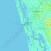
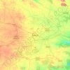
Topografische Karte Kerala
Klicken Sie auf die Karte, um die Höhe anzuzeigen.
Kerala
The state is wedged between the Laccadive Sea and the Western Ghats. Lying between northern latitudes 8°18' and 12°48' and eastern longitudes 74°52' and 77°22', Kerala experiences humid tropical rainforest climate with some cyclones. The state has a coast of 590 km (370 mi) and the width of the state varies between 11 and 121 kilometres (7 and 75 mi). Geographically, Kerala can be divided into three climatically distinct regions: the eastern highlands; rugged and cool mountainous terrain, the central mid-lands; rolling hills, and the western lowlands; coastal plains. Pre-Cambrian and Pleistocene geological formations compose the bulk of Kerala's terrain. A catastrophic flood in Kerala in 1341 CE drastically modified its terrain and consequently affected its history; it also created a natural harbour for spice transport. The eastern region of Kerala consists of high mountains, gorges and deep-cut valleys immediately west of the Western Ghats' rain shadow. 41 of Kerala's west-flowing rivers, and 3 of its east-flowing ones originate in this region. The Western Ghats form a wall of mountains interrupted only near Palakkad; hence also known Palghat, where the Palakkad Gap breaks. The Western Ghats rise on average to 1,500 metres (4,900 feet) above sea level, while the highest peaks reach around 2,500 metres (8,200 feet). Anamudi in the Idukki district is the highest peak in south India, is at an elevation of 2,695 m (8,842 ft). The Western Ghats mountain chain is recognised as one of the world's eight "hottest hotspots" of biological diversity and is listed among UNESCO World Heritage Sites. The chain's forests are considered to be older than the Himalaya mountains. The Athirappilly Falls, which is situated on the background of Western Ghat mountain ranges, is also known as The Niagara of India. It is located in the Chalakudy River and is the largest waterfall in the state. Wayanad is the sole Plateau in Kerala. The eastern regions in the districts of Wayanad, Malappuram (Chaliyar valley at Nilambur), and Palakkad (Attappadi Valley), which together form parts of the Nilgiri Biosphere Reserve and a continuation of the Mysore Plateau, are known for natural Gold fields, along with the adjoining districts of Karnataka. Minerals including Ilmenite, Monazite, Thorium, and Titanium, are found in the coastal belt of Kerala. Kerala's coastal belt of Karunagappally is known for high background radiation from thorium-containing monazite sand. In some coastal panchayats, median outdoor radiation levels are more than 4 mGy/yr and, in certain locations on the coast, it is as high as 70 mGy/yr.
Über diese Karte
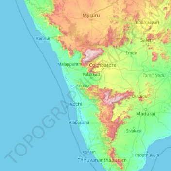
Name: Topografische Karte Kerala, Höhe, Relief.
Ort: Kerala, India (8.29353 74.86407 12.79606 77.41236)
Durchschnittliche Höhe: 251 m
Minimale Höhe: -4 m
Maximale Höhe: 2.557 m
Andere topografische Karten
Klicken Sie auf eine Karte, um ihre Topografie, ihre Höhe und ihr Relief anzuzeigen.


Chandrasekharapuram
India > Andhra Pradesh > Tallladumma > Chandrasekharapuram
Durchschnittliche Höhe: 133 m
Maharashtra
Maharashtra is the third largest state by area in India. The Western Ghats better known as Sahyadri, are a hilly range running parallel to the coast, at an average elevation of 1,200 metres (4,000 ft). Kalsubai, a peak in the Sahyadris, near Nashik city is the highest elevated point in Maharashtra. To the west…
Durchschnittliche Höhe: 478 m

Nagarjun Sagar Right Canal
India > Andhra Pradesh > Macherla > Javuk Thanda
Durchschnittliche Höhe: 180 m
Bhubaneshwar
India > Odisha > Bhubaneswar (M.Corp.)
Bhubaneswar is in Khordha district of Odisha. It is in the eastern coastal plains, along the axis of the Eastern Ghats mountains. The city has an average altitude of 45 m (148 ft) above sea level. It lies southwest of the Mahanadi River that forms the northern boundary of Bhubaneswar metropolitan area, within…
Durchschnittliche Höhe: 30 m
Guwahati
Professor Abani Kumar Bhagawati of Gauhati University stated that since before there were sufficient wetlands to absorb rainwater and channels to carry excess water to the Brahmaputra, the city did not experience floods. However, human interference has disrupted the natural topography, leading to the current…
Durchschnittliche Höhe: 113 m
Dehradun
India > Uttarakhand > Dehradun
The city of Dehradun mainly lies in Doon Valley and is at a varying height from 410 m (1,350 ft) in Clement Town to above 700 m (2,300 ft) at Malsi which is 15 km (9.3 mi) from the city. However, the average elevation is 450 m (1,480 ft) above sea level. Malsi is the starting point of Lesser Himalayan Range…
Durchschnittliche Höhe: 904 m
Mumbai
Mumbai lies at the mouth of the Ulhas River on the western coast of India, in the coastal region known as the Konkan. It sits on Salsette Island (Sashti Island), which it partially shares with the Thane district. Mumbai is bounded by the Arabian Sea to the west. Many parts of the city lie just above sea level,…
Durchschnittliche Höhe: 13 m
Kolhapur
India > Maharashtra > Karvir
Kolhapur is an inland city located in south-west Maharashtra state, 373 km (232 mi) south of Mumbai and 228 km (142 mi) south of Pune, 615 km (382 mi) north-west of Bengaluru and 530 km (330 mi) west of Hyderabad. Within Maharashtra, Kolhapur's nearest cities and towns are Ichalkaranji 27 km (17 mi), Kodoli 35…
Durchschnittliche Höhe: 592 m
Western Ghats
The range starts near south of the Tapti river and runs approximately 1,600 km (990 mi) through the states of Gujarat, Maharashtra, Karnataka, Goa, Kerala and Tamil Nadu ending at Marunthuvazh Malai, Swamithope near the southern tip of India. These hills cover 160,000 km2 (62,000 sq mi) and form the catchment…
Durchschnittliche Höhe: 2.225 m

Chandigarh
India > Chandigarh > Chandigarh
Chandigarh is located by the foothills of the Shivalik Range of the Himalayas in northwest India. It covers an area of approximately 114 km2. It borders the states of Punjab and Haryana. The exact geographic coordinates of Chandigarh are 30°44′N 76°47′E / 30.74°N 76.79°E / 30.74; 76.79. It has…
Durchschnittliche Höhe: 378 m
Bhopal
India > Madhya Pradesh > Huzur Tahsil
Bhopal has an average elevation of 500 metres (1401 ft) and is located in the central part of India, just north of the upper limit of the Vindhya mountain ranges. Located on the Malwa plateau, it is higher than the north Indian plains and the land rises towards the Vindhya Range to the south. The city has…
Durchschnittliche Höhe: 498 m



Devagiri Fort
India > Maharashtra > Chhatrapati Sambhajinagar > Daulatabad
Durchschnittliche Höhe: 606 m
Rani
India > Rajasthan > Rani Tehsil
Rani is located at 25°22′N 73°18′E / 25.37°N 73.3°E / 25.37; 73.3.[3] It has an average elevation of 273 metres (895 feet).
Durchschnittliche Höhe: 279 m
Patna
India > Bihar > Patna Rural
Patna is on the southern bank of the river Ganges. The total area of Patna is 250 km2 (97 sq mi). Of this, the municipal area constitutes 109.218 km2 (42.169 sq mi). The suburban area covers 140.782 km2 (54.356 sq mi). It has an average elevation of 53 m (174 ft). A characteristic feature of the geography of…
Durchschnittliche Höhe: 51 m
Kollam
Cosmas Indicopleustes, a Greek Nestorian sailor, in his book the Christian Topography who visited the Malabar Coast in 550, mentions an enclave of Christian believers in Male (Malabar Coast). He writes, "In the island of Tabropane (Ceylon), there is a church of Christians, and clerics and faithful. Likewise at…
Durchschnittliche Höhe: 11 m



Owk
India > Andhra Pradesh > Owk Mandal
Owk is located at 15°13′00″N 78°07′00″E / 15.2167°N 78.1167°E / 15.2167; 78.1167. It has an average elevation of 194 meters (639 feet).
Durchschnittliche Höhe: 223 m
Mettupalayam
India > Tamil Nadu > Mettupalayam
Mettupalayam is located at 11°18′00″N 76°57′00″E / 11.3000°N 76.9500°E / 11.3000; 76.9500. It has an average elevation of 314 metres (1033 feet). Mettupalayam is situated on the bank of Bhavani River at the foot of the Nilgiri mountains.
Durchschnittliche Höhe: 321 m

Visakhapatnam
India > Andhra Pradesh > Visakhapatnam Urban
The city is situated between the Eastern Ghats and the Bay of Bengal. The city coordinates lies between 17.7041 N and 83.2977 E. The city's area is 682 km2. The average elevation is 45 metres. Visakhpatnam is situated in Coastal Andhra Region.
Durchschnittliche Höhe: 35 m

Sivakasi
India > Tamil Nadu > Sivakasi
Sivakasi is located at 9°27′00″N 77°49′00″E / 9.45°N 77.8167°E / 9.45; 77.8167 and has an average elevation of 101 metres (331 feet). The city is located in Virudhunagar district of the South Indian state, Tamil Nadu, at a distance of 74 km (46 mi) from Madurai. Sivakasi is located to the…
Durchschnittliche Höhe: 104 m
Surat
India > Gujarat > Katargam Taluka > Surat
Surat is a port city situated on the banks of the Tapi river. Damming of the Tapi caused the original port facilities to close; the nearest port is now in the Magadalla and Hazira area of Surat Metropolitan Region.It has famous beach called 'Dumas Beach' located in Hazira. The city is located at 21°10′N…
Durchschnittliche Höhe: 11 m



Leh
Leh (/ˈlɛ/) (Ladakhi: གླེ) is the joint capital and largest city of Ladakh, a union territory of India. Leh, located in the Leh district, was also the historical capital of the Kingdom of Ladakh, the seat of which was in the Leh Palace, the former residence of the royal family of Ladakh, built in the…
Durchschnittliche Höhe: 4.294 m
Mangaluru
India > Karnataka > Mangaluru taluk
Mangalore is also the administrative headquarters of the Dakshina Kannada district; it is a commercial, industrial, educational, healthcare, and startup hub. The city's international airport is the second-largest and second-busiest airport in Karnataka. Mangalore City Corporation is responsible for the civic…
Durchschnittliche Höhe: 25 m
Kolkata
Spread roughly north–south along the east bank of the Hooghly River, Kolkata sits within the lower Ganges Delta of eastern India approximately 75 km (47 mi) west of the international border with Bangladesh; the city's elevation is 1.5–9 m (5–30 ft). Much of the city was originally a wetland that was…
Durchschnittliche Höhe: 5 m








Asind
India > Rajasthan > Asind Tehsil
Asind is located at 25°44′N 74°20′E / 25.73°N 74.33°E / 25.73; 74.33. It has an average elevation of 467 metres (1532 feet). Asind is also the name of a Chinese Company located in Hangzhou, Zhejiang Province of China. Mines is Located in Village Shambhugarh, Daultgarh, Roop-pura, Barana,…
Durchschnittliche Höhe: 479 m


Eastern Ghats
India > Odisha > Ramagiri > Burakhat
The Eastern Ghats is a mountain range that stretches 1,750 km (1,090 mi) along the eastern coast of the Indian peninsula. Covering an area of 75,000 km2 (29,000 sq mi), it traverses the states of Odisha, Telangana, Andhra Pradesh, Karnataka, and Tamil Nadu. The range forms a discontinuous chain of mountains…
Durchschnittliche Höhe: 1.130 m

Navi Mumbai
India > Maharashtra > Thane > Navi Mumbai
Navi Mumbai (Marathi pronunciation: , also known by its former name New Bombay), is a planned city off the west coast of the Indian state of Maharashtra in Konkan division. The city is divided into two parts, North Navi Mumbai and South Navi Mumbai, for the individual development of Panvel Mega City, which…
Durchschnittliche Höhe: 30 m
Vellore
India > Tamil Nadu > Vellore
Vellore is at 12°55′N 79°08′E / 12.92°N 79.13°E / 12.92; 79.13, 220m above sea level. The city has a tropical savanna climate. It is in the Vellore district of the South Indian state, Tamil Nadu, 135 km (84 mi) west of the state capital Chennai and 30 km (19 mi) kms South of its twin city…
Durchschnittliche Höhe: 283 m
Ranchi
Ranchi lies at 23°22′N 85°20′E / 23.36°N 85.33°E / 23.36; 85.33 near to the Tropic of Cancer. The city covers an area of 175 km2 (68 sq mi) and its average elevation is 651 m above sea level. Ranchi is located in the southern part of the Chota Nagpur plateau, which is the eastern section of…
Durchschnittliche Höhe: 648 m