Geolokalisieren

Topografische Karte Jovim

Klicken Sie auf die Karte, um die Höhe anzuzeigen.

Über diese Karte
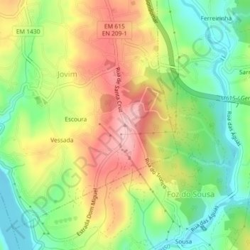
Name: Topografische Karte Jovim, Höhe, Relief.

Ort: Jovim, Gondomar, Porto, 4515-184, Portugal (41.10688 -8.50939 41.10698 -8.50929)

Durchschnittliche Höhe: 80 m

Minimale Höhe: 2 m

Maximale Höhe: 171 m

Andere topografische Karten

Klicken Sie auf eine Karte, um ihre Topografie, ihre Höhe und ihr Relief anzuzeigen.

Melres e Medas

Portugal > Porto > Gondomar

Durchschnittliche Höhe: 108 m

São Pedro da Cova

Portugal > Porto > Gondomar

Durchschnittliche Höhe: 135 m

Baguim do Monte (Rio Tinto)

Portugal > Porto > Gondomar

Durchschnittliche Höhe: 143 m

Valbom

Portugal > Porto > Gondomar

Durchschnittliche Höhe: 53 m

Covelo

Portugal > Porto > Gondomar

Durchschnittliche Höhe: 102 m

Fânzeres

Portugal > Porto > Gondomar

Durchschnittliche Höhe: 131 m

Lomba

Portugal > Porto > Gondomar

Durchschnittliche Höhe: 128 m

Melres

Portugal > Porto > Gondomar

Durchschnittliche Höhe: 139 m

Foz do Sousa

Portugal > Porto > Gondomar

Durchschnittliche Höhe: 80 m

São Cosme

Portugal > Porto > Gondomar

Durchschnittliche Höhe: 97 m

Medas

Portugal > Porto > Gondomar

Durchschnittliche Höhe: 88 m

Lomba

Portugal > Porto > Gondomar

Durchschnittliche Höhe: 128 m

São Pedro da Cova

Portugal > Porto > Gondomar

Durchschnittliche Höhe: 137 m

Melres

Portugal > Porto > Gondomar

Durchschnittliche Höhe: 139 m

Baguim do Monte (Rio Tinto)

Portugal > Porto > Gondomar

Durchschnittliche Höhe: 143 m

Rüsten Sie sich für Ihr nächstes Abenteuer:

🪶Ultraleicht Schlafsystem - Leichtgewicht Schlafausrüstung
🔒Sicheres Fahrradschloss - Hoher Diebstahlschutz für teure E-Bikes und MTBs
🧠Survival Bücher - Outdoor Überlebenswissen
🥾Leichte Wanderstiefel - Komfortable Stiefel für Tageswanderungen
🍳Kochset Outdoor - Komplettes Kochset für Camping

Als Amazon-Partner verdient diese Website an qualifizierten Käufen, ohne dass Ihnen zusätzliche Kosten entstehen.