
Topografische Karte Oro Valley
Interaktive Karte
Klicken Sie auf die Karte, um die Höhe anzuzeigen.
Über diese Karte
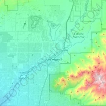
Name: Topografische Karte Oro Valley, Höhe, Relief.
Durchschnittliche Höhe: 969 m
Minimale Höhe: 686 m
Maximale Höhe: 2.201 m
Andere topografische Karten
Klicken Sie auf eine Karte, um ihre Topografie, ihre Höhe und ihr Relief anzuzeigen.
Ajo
Estados Unidos da América > Arizona > Pima County
Ajo, Pima County, Arizona, 85321, Estados Unidos da América
Durchschnittliche Höhe: 541 m
Tucson
Estados Unidos da América > Arizona > Pima County > Tucson
Tucson, Pima County, Arizona, 85701, Estados Unidos da América
Durchschnittliche Höhe: 836 m
Tucson
Estados Unidos da América > Arizona > Pima County > Tucson
Tucson, Pima County, Arizona, Estados Unidos da América
Durchschnittliche Höhe: 821 m