
Topografische Karte Denkanikottai
Interaktive Karte
Klicken Sie auf die Karte, um die Höhe anzuzeigen.
Über diese Karte
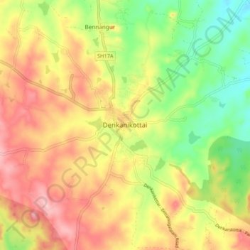
Name: Topografische Karte Denkanikottai, Höhe, Relief.
Ort: Denkanikottai, Krishnagiri District, Tamil Nadu, 635107, India (12.48709 77.75262 12.56709 77.83262)
Durchschnittliche Höhe: 872 m
Minimale Höhe: 788 m
Maximale Höhe: 953 m
Denkanikottai also known as Thenkanikottai is a semi-urban Panchayat Town in Krishnagiri district in the state of Tamil Nadu, India. It is the headquarters of Denkanikottai Taluk. Its altitude 879 m (2,884 ft) elevation above the sea level. It is a multicultural town with a mix of linguistic groups. Tamil is the official and spoken language. There are a significant number of Kannada, Urdu and Telugu and speakers in the town as it is very near to Karnataka State bordering it. The place is named after the legend of Betrayaswamy Temple located in the centre of the town.
Andere topografische Karten
Klicken Sie auf eine Karte, um ihre Topografie, ihre Höhe und ihr Relief anzuzeigen.
Bettamugilalam
India > Tamil Nadu > Denkanikottai
Bettamugilalam, Denkanikottai, Krishnagiri District, Tamil Nadu, India
Durchschnittliche Höhe: 1.059 m
Rayakottai
India > Tamil Nadu > Denkanikottai
Rayakottai, Denkanikottai, Krishnagiri District, Tamil Nadu, India
Durchschnittliche Höhe: 706 m
Kelamangalam
India > Tamil Nadu > Denkanikottai
Kelamangalam, Denkanikottai, Krishnagiri District, Tamil Nadu, 635113, India
Durchschnittliche Höhe: 807 m
Gumalapura
India > Tamil Nadu > Denkanikottai
Gumalapura, Denkanikottai, Krishnagiri District, Tamil Nadu, 635118, India
Durchschnittliche Höhe: 938 m
Thalli
India > Tamil Nadu > Denkanikottai
Thalli, Denkanikottai, Krishnagiri District, Tamil Nadu, 635118, India
Durchschnittliche Höhe: 916 m
Chinnapariddiplaiyam
India > Tamil Nadu > Denkanikottai > Chinnapariddiplaiyam
Chinnapariddiplaiyam, Denkanikottai, Krishnagiri District, Tamil Nadu, India
Durchschnittliche Höhe: 885 m