
Topografische Karte Hèches
Interaktive Karte
Klicken Sie auf die Karte, um die Höhe anzuzeigen.
Über diese Karte
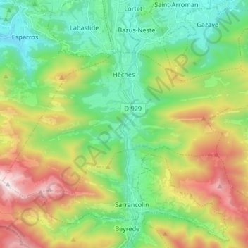
Name: Topografische Karte Hèches, Höhe, Relief.
Durchschnittliche Höhe: 945 m
Minimale Höhe: 450 m
Maximale Höhe: 1.886 m
Andere topografische Karten
Klicken Sie auf eine Karte, um ihre Topografie, ihre Höhe und ihr Relief anzuzeigen.
Lac de Gaube
France > Occitania > Hautes Pyrenees > Cauterets
Lac de Gaube, Cauterets, Argelès-Gazost, Hautes Pyrenees, Occitania, Metropolitan France, 65110, France
Durchschnittliche Höhe: 2.079 m
Gavarnie-Gèdre
France > Occitania > Hautes Pyrenees
Gavarnie-Gèdre, Argelès-Gazost, Hautes Pyrenees, Occitania, Metropolitan France, 65120, France
Durchschnittliche Höhe: 2.115 m
Marsac
France > Occitania > Hautes Pyrenees
Marsac, Tarbes, Hautes Pyrenees, Occitania, Metropolitan France, 65500, France
Durchschnittliche Höhe: 247 m
Payolle
France > Occitania > Hautes Pyrenees > Campan
Payolle, Campan, Bagnères-de-Bigorre, Hautes Pyrenees, Occitania, Metropolitan France, 65710, France
Durchschnittliche Höhe: 1.281 m
Maubourguet
France > Occitania > Hautes Pyrenees
Maubourguet, Tarbes, Hautes Pyrenees, Occitania, Metropolitan France, 65700, France
Durchschnittliche Höhe: 186 m
Vue sur Cascades et Pont d'Espagne
France > Occitania > Hautes Pyrenees > Cauterets
Vue sur Cascades et Pont d'Espagne, Pont d'Espagne, Cauterets, Argelès-Gazost, Hautes Pyrenees, Occitania, Metropolitan France, 65110, France
Durchschnittliche Höhe: 1.827 m
Pic du lac noir
France > Occitania > Hautes Pyrenees > Luz-Saint-Sauveur
Pic du lac noir, Luz-Saint-Sauveur, Argelès-Gazost, Hautes Pyrenees, Occitania, Metropolitan France, 65120, France
Durchschnittliche Höhe: 2.440 m
Trébons
France > Occitania > Hautes Pyrenees
Trébons, Bagnères-de-Bigorre, Hautes Pyrenees, Occitania, Metropolitan France, 65200, France
Durchschnittliche Höhe: 549 m
Barèges
France > Occitania > Hautes Pyrenees
Barèges, Argelès-Gazost, Hautes Pyrenees, Occitania, Metropolitan France, 65120, France
Durchschnittliche Höhe: 1.844 m
Sers
France > Occitania > Hautes Pyrenees
Sers, Argelès-Gazost, Hautes Pyrenees, Occitania, Metropolitan France, 65120, France
Durchschnittliche Höhe: 1.668 m
Monléon-Magnoac
France > Occitania > Hautes Pyrenees
Monléon-Magnoac, Tarbes, Hautes Pyrenees, Occitania, Metropolitan France, 65670, France
Durchschnittliche Höhe: 403 m
Sarp
France > Occitania > Hautes Pyrenees
Sarp, Bagnères-de-Bigorre, Hautes Pyrenees, Occitania, Metropolitan France, 65370, France
Durchschnittliche Höhe: 498 m
Vignec
France > Occitania > Hautes Pyrenees
Vignec, Bagnères-de-Bigorre, Hautes Pyrenees, Occitania, Metropolitan France, 65170, France
Durchschnittliche Höhe: 1.232 m
Vic-en-Bigorre
France > Occitania > Hautes Pyrenees
Vic-en-Bigorre, Tarbes, Hautes Pyrenees, Occitania, Metropolitan France, 65500, France
Durchschnittliche Höhe: 225 m
Arcizans-Dessus
France > Occitania > Hautes Pyrenees
Arcizans-Dessus, Argelès-Gazost, Hautes Pyrenees, Occitania, Metropolitan France, 65400, France
Durchschnittliche Höhe: 1.036 m
Gèdre
France > Occitania > Hautes Pyrenees > Gavarnie-Gèdre
Gèdre, Gavarnie-Gèdre, Argelès-Gazost, Hautes Pyrenees, Occitania, Metropolitan France, 65120, France
Durchschnittliche Höhe: 2.136 m
Bettes
France > Occitania > Hautes Pyrenees
Bettes, Bagnères-de-Bigorre, Hautes Pyrenees, Occitania, Metropolitan France, 65130, France
Durchschnittliche Höhe: 541 m
Castelnau-Magnoac
France > Occitania > Hautes Pyrenees
Castelnau-Magnoac, Tarbes, Hautes Pyrenees, Occitania, Metropolitan France, 65230, France
Durchschnittliche Höhe: 307 m
Ségus
France > Occitania > Hautes Pyrenees
Ségus, Argelès-Gazost, Hautes Pyrenees, Occitania, Metropolitan France, 65100, France
Durchschnittliche Höhe: 687 m
Dours
France > Occitania > Hautes Pyrenees
Dours, Tarbes, Hautes Pyrenees, Occitania, Metropolitan France, 65350, France
Durchschnittliche Höhe: 275 m
Loures-Barousse
France > Occitania > Hautes Pyrenees
Loures-Barousse, Bagnères-de-Bigorre, Hautes Pyrenees, Occitania, Metropolitan France, 65370, France
Durchschnittliche Höhe: 455 m
Trie-sur-Baïse
France > Occitania > Hautes Pyrenees > Trie-sur-Baïse
Trie-sur-Baïse, Tarbes, Hautes Pyrenees, Occitania, Metropolitan France, 65220, France
Durchschnittliche Höhe: 282 m
Aragnouet
France > Occitania > Hautes Pyrenees
Aragnouet, Bagnères-de-Bigorre, Hautes Pyrenees, Occitania, Metropolitan France, 65170, France
Durchschnittliche Höhe: 2.055 m
Nistos
France > Occitania > Hautes Pyrenees > Nistos
Nistos, Bagnères-de-Bigorre, Hautes Pyrenees, Occitania, Metropolitan France, 65150, France
Durchschnittliche Höhe: 1.004 m
Germ
France > Occitania > Hautes Pyrenees
Germ, Bagnères-de-Bigorre, Hautes Pyrenees, Occitania, Metropolitan France, 65240, France
Durchschnittliche Höhe: 1.677 m
Cirque de Gavarnie
France > Occitania > Hautes Pyrenees > Gavarnie-Gèdre > Gavarnie
Cirque de Gavarnie, Gavarnie, Gavarnie-Gèdre, Argelès-Gazost, Hautes Pyrenees, Occitania, Metropolitan France, 65120, France
Durchschnittliche Höhe: 2.364 m
Gavarnie
France > Occitania > Hautes Pyrenees > Gavarnie-Gèdre
Gavarnie, Gavarnie-Gèdre, Argelès-Gazost, Hautes Pyrenees, Occitania, Metropolitan France, 65120, France
Durchschnittliche Höhe: 2.119 m
Marseillan
France > Occitania > Hautes Pyrenees
Marseillan, Tarbes, Hautes Pyrenees, Occitania, Metropolitan France, 65350, France
Durchschnittliche Höhe: 242 m
Viger
France > Occitania > Hautes Pyrenees > Viger
Viger, Argelès-Gazost, Hautes Pyrenees, Occitania, Metropolitan France, 65100, France
Durchschnittliche Höhe: 543 m
Uzer
France > Occitania > Hautes Pyrenees > Uzer
Uzer, Bagnères-de-Bigorre, Hautes Pyrenees, Occitania, Metropolitan France, 65200, France
Durchschnittliche Höhe: 561 m
Vallée du Marcadau
France > Occitania > Hautes Pyrenees > Cauterets
Vallée du Marcadau, Cauterets, Argelès-Gazost, Hautes Pyrenees, Occitania, Metropolitan France, 65110, France
Durchschnittliche Höhe: 1.993 m
Pierrefitte-Nestalas
France > Occitania > Hautes Pyrenees > Pierrefitte-Nestalas > Pierrefitte-Nestalas
Pierrefitte-Nestalas, Argelès-Gazost, Hautes Pyrenees, Occitania, Metropolitan France, 65260, France
Durchschnittliche Höhe: 712 m
Ris
France > Occitania > Hautes Pyrenees > Ris
Ris, Bagnères-de-Bigorre, Hautes Pyrenees, Occitania, Metropolitan France, 65590, France
Durchschnittliche Höhe: 1.093 m
Arné
France > Occitania > Hautes Pyrenees > Arné
Arné, Bagnères-de-Bigorre, Hautes Pyrenees, Occitania, Metropolitan France, 65670, France
Durchschnittliche Höhe: 491 m
Salles
France > Occitania > Hautes Pyrenees
Salles, Argelès-Gazost, Hautes Pyrenees, Occitania, Metropolitan France, 65400, France
Durchschnittliche Höhe: 859 m
Lagarde
France > Occitania > Hautes Pyrenees > Lagarde
Lagarde, Tarbes, Hautes Pyrenees, Occitania, Metropolitan France, 65320, France
Durchschnittliche Höhe: 281 m
Barry
France > Occitania > Hautes Pyrenees
Barry, Tarbes, Hautes Pyrenees, Occitania, Metropolitan France, 65380, France
Durchschnittliche Höhe: 431 m
Lourdes
France > Occitania > Hautes Pyrenees
Lourdes, Argelès-Gazost, Hautes Pyrenees, Occitania, Metropolitan France, 65100, France
Durchschnittliche Höhe: 514 m
Loudenvielle
France > Occitania > Hautes Pyrenees > Loudenvielle
Loudenvielle, Bagnères-de-Bigorre, Hautes Pyrenees, Occitania, Metropolitan France, 65510, France
Durchschnittliche Höhe: 1.974 m
Tarbes
France > Occitania > Hautes Pyrenees
Tarbes, Hautes Pyrenees, Occitania, Metropolitan France, 65000, France
Durchschnittliche Höhe: 308 m
Estaing
France > Occitania > Hautes Pyrenees
Estaing, Argelès-Gazost, Hautes Pyrenees, Occitania, Metropolitan France, 65400, France
Durchschnittliche Höhe: 1.782 m
Eget Village
France > Occitania > Hautes Pyrenees > Aragnouet > Eget Village
Eget Village, Aragnouet, Bagnères-de-Bigorre, Hautes Pyrenees, Occitania, Metropolitan France, 65170, France
Durchschnittliche Höhe: 1.560 m
Sost
France > Occitania > Hautes Pyrenees
Sost, Bagnères-de-Bigorre, Hautes Pyrenees, Occitania, Metropolitan France, 65370, France
Durchschnittliche Höhe: 1.284 m
Cauterets
France > Occitania > Hautes Pyrenees
Cauterets, Argelès-Gazost, Hautes Pyrenees, Occitania, Metropolitan France, 65110, France
Durchschnittliche Höhe: 1.817 m
Juillan
France > Occitania > Hautes Pyrenees
Juillan, Tarbes, Hautes Pyrenees, Occitania, Metropolitan France, 65290, France
Durchschnittliche Höhe: 338 m
Pic du Midi de Bigorre
France > Occitania > Hautes Pyrenees > Bagnères-de-Bigorre
Pic du Midi de Bigorre, Bagnères-de-Bigorre, Hautes Pyrenees, Occitania, Metropolitan France, France
Durchschnittliche Höhe: 2.280 m
Viella
France > Occitania > Hautes Pyrenees > Viella
Viella, Argelès-Gazost, Hautes Pyrenees, Occitania, Metropolitan France, 65120, France
Durchschnittliche Höhe: 1.109 m
Samuran
France > Occitania > Hautes Pyrenees
Samuran, Bagnères-de-Bigorre, Hautes Pyrenees, Occitania, Metropolitan France, 65370, France
Durchschnittliche Höhe: 713 m
Esterre
France > Occitania > Hautes Pyrenees
Esterre, Argelès-Gazost, Hautes Pyrenees, Occitania, Metropolitan France, 65120, France
Durchschnittliche Höhe: 965 m