Geolokalisieren
👉 Easily get elevation data in JSON, GeoTIFF and KML formats using Elevation API
Vielen Dank für die Unterstützung dieser Website ❤️
Spenden

Rüsten Sie sich für Ihr nächstes Abenteuer:

Als Amazon-Partner verdient diese Website an qualifizierten Käufen, ohne dass Ihnen zusätzliche Kosten entstehen.

Topografische Karte Round Rock

Klicken Sie auf die Karte, um die Höhe anzuzeigen.

Round Rock

Round Rock sits at an approximate elevation of 735 feet above sea level and spans a diverse terrain shaped by the Balcones Escarpment. This geological fault line divides the city into two distinct landscapes: the eastern side lies on the relatively flat and fertile Blackland Prairie, characterized by deep, clay-rich soils ideal for agriculture. In contrast, the western side features the rugged, limestone-rich topography of the Texas Hill Country, where rolling hills and exposed bedrock are common. This variance in elevation and terrain not only creates a unique visual landscape but also influences local ecosystems and land use across the city.

👉 Easily get elevation data in JSON, GeoTIFF and KML formats using Elevation API
Vielen Dank für die Unterstützung dieser Website ❤️
Spenden

Über diese Karte

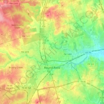
Name: Topografische Karte Round Rock, Höhe, Relief.

Ort: Round Rock, Williamson County, Texas, United States (30.46829 -97.76484 30.59378 -97.59005)

Durchschnittliche Höhe: 242 m

Minimale Höhe: 191 m

Maximale Höhe: 306 m

👉 Easily get elevation data in JSON, GeoTIFF and KML formats using Elevation API
Vielen Dank für die Unterstützung dieser Website ❤️
Spenden

Rüsten Sie sich für Ihr nächstes Abenteuer:

Als Amazon-Partner verdient diese Website an qualifizierten Käufen, ohne dass Ihnen zusätzliche Kosten entstehen.

Andere topografische Karten

Klicken Sie auf eine Karte, um ihre Topografie, ihre Höhe und ihr Relief anzuzeigen.

Lakeline Park

United States > Texas > Williamson County > Cedar Park

Durchschnittliche Höhe: 284 m

Jonah

United States > Texas > Williamson County

Durchschnittliche Höhe: 190 m

Vielen Dank für die Unterstützung dieser Website ❤️
Spenden

Rüsten Sie sich für Ihr nächstes Abenteuer:

Als Amazon-Partner verdient diese Website an qualifizierten Käufen, ohne dass Ihnen zusätzliche Kosten entstehen.

Georgetown

United States > Texas > Williamson County > Georgetown

The city is located on the northeastern edge of Texas Hill Country. Portions of Georgetown are located on either side of the Balcones Escarpment, a fault line in which the areas roughly east of IH-35 are flat and characterized by having black, fertile soils of the Blackland Prairie, and the west side of the…

Durchschnittliche Höhe: 228 m

Leander

United States > Texas > Williamson County > Leander > Leander

Durchschnittliche Höhe: 304 m

Cedar Park

United States > Texas > Williamson County > Cedar Park > Cedar Park

Durchschnittliche Höhe: 292 m

Vielen Dank für die Unterstützung dieser Website ❤️
Spenden

Rüsten Sie sich für Ihr nächstes Abenteuer:

Als Amazon-Partner verdient diese Website an qualifizierten Käufen, ohne dass Ihnen zusätzliche Kosten entstehen.

Round Rock

United States > Texas > Williamson County > Round Rock

The city straddles the Balcones Escarpment, a fault line in which the areas roughly east of Interstate 35 are flat and characterized by having black, fertile soils of the Blackland Prairie, and the west side of the Escarpment, which consists mostly of hilly, karst-like terrain with little topsoil and higher…

Durchschnittliche Höhe: 236 m

Rüsten Sie sich für Ihr nächstes Abenteuer:

🛡️Kniebandage für Wanderer - Unterstützung bei steilen Abstiegen und Gelenkproblemen
🧥Regenponcho für Wanderer - Großflächiger Schutz, passt über den Rucksack
🛏️Schlafsack - Komfortabler Schlafsack für Camping
🛠️Fahrrad Multitool - Schnelle Reparaturen unterwegs selbst durchführen
🧥Hardshelljacke Damen - Wind- und wasserdichte Funktionsjacke

Als Amazon-Partner verdient diese Website an qualifizierten Käufen, ohne dass Ihnen zusätzliche Kosten entstehen.