
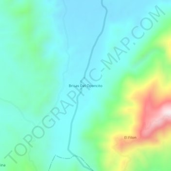
Topografische Karte Brisas Del Oponcito
Interaktive Karte
Klicken Sie auf die Karte, um die Höhe anzuzeigen.
Über diese Karte
Name: Topografische Karte Brisas Del Oponcito, Höhe, Relief.
Durchschnittliche Höhe: 347 m
Minimale Höhe: 202 m
Maximale Höhe: 839 m
Andere topografische Karten
Klicken Sie auf eine Karte, um ihre Topografie, ihre Höhe und ihr Relief anzuzeigen.
Guamales
Colombia > Santander > San Vicente de Chucurí
Guamales, San Vicente de Chucurí, Yariguíes, Santander, RAP Gran Santander, Colombia
Durchschnittliche Höhe: 1.232 m
La Colorada
Colombia > Santander > San Vicente de Chucurí
La Colorada, San Vicente de Chucurí, Yariguíes, Santander, RAP Gran Santander, Colombia
Durchschnittliche Höhe: 112 m
Llana Caliente
Colombia > Santander > San Vicente de Chucurí
Llana Caliente, San Vicente de Chucurí, Yariguíes, Santander, RAP Gran Santander, Colombia
Durchschnittliche Höhe: 211 m
Llana Fria - Borneo
Colombia > Santander > San Vicente de Chucurí
Llana Fria - Borneo, San Vicente de Chucurí, Yariguíes, Santander, RAP Gran Santander, Colombia
Durchschnittliche Höhe: 621 m
Tempestuosa
Colombia > Santander > San Vicente de Chucurí > Tempestuosa
Tempestuosa, San Vicente de Chucurí, Yariguíes, Santander, Colombia
Durchschnittliche Höhe: 226 m