
Topografische Karte Montevallo
Interaktive Karte
Klicken Sie auf die Karte, um die Höhe anzuzeigen.
Über diese Karte
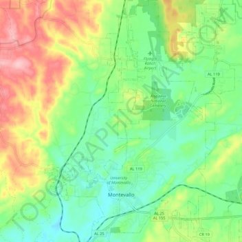
Name: Topografische Karte Montevallo, Höhe, Relief.
Ort: Montevallo, Shelby County, Alabama, 35115, United States (33.08322 -86.89807 33.17238 -86.81374)
Durchschnittliche Höhe: 162 m
Minimale Höhe: 106 m
Maximale Höhe: 255 m
Andere topografische Karten
Klicken Sie auf eine Karte, um ihre Topografie, ihre Höhe und ihr Relief anzuzeigen.
Westover
United States > Alabama > Shelby County
Westover, Shelby County, Alabama, 35185, United States
Durchschnittliche Höhe: 153 m
Hardy
United States > Alabama > Shelby County > Alabaster
Hardy, Alabaster, Shelby County, Alabama, 35007, United States
Durchschnittliche Höhe: 157 m
Alabaster
United States > Alabama > Shelby County > Alabaster
Alabaster, Shelby County, Alabama, 35007, United States
Durchschnittliche Höhe: 173 m
Ozan
United States > Alabama > Shelby County > Ozan
Ozan, Shelby County, Alabama, 35040, United States
Durchschnittliche Höhe: 168 m
Meadowbrook
United States > Alabama > Shelby County > Meadowbrook
Meadowbrook, Shelby County, Alabama, 35242, United States
Durchschnittliche Höhe: 192 m
Pelham
United States > Alabama > Shelby County
Pelham, Shelby County, Alabama, 35124, United States
Durchschnittliche Höhe: 173 m