
Topografische Karte Cannon Beach
Interaktive Karte
Klicken Sie auf die Karte, um die Höhe anzuzeigen.
Über diese Karte
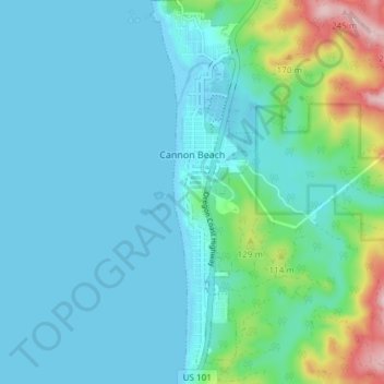
Name: Topografische Karte Cannon Beach, Höhe, Relief.
Ort: Cannon Beach, Clatsop County, Oregon, United States (45.85893 -123.97004 45.91103 -123.94945)
Durchschnittliche Höhe: 42 m
Minimale Höhe: -3 m
Maximale Höhe: 250 m
Cannon Beach is recognized by the well-known landmark Haystack Rock, located southwest of downtown Cannon Beach. This sea stack has an elevation of 235 feet (72 m) and is often accessible at low tide, especially in the summertime. There is a small cave system that penetrates its igneous rock that can be seen from the coastline. The rock is also protected as part of Oregon Islands National Wildlife Refuge and events are not allowed within 100 feet (30 m) of either side of the rock. Near Haystack Rock are the Needles, two tall rocks rising straight out of the water.
Andere topografische Karten
Klicken Sie auf eine Karte, um ihre Topografie, ihre Höhe und ihr Relief anzuzeigen.
Astoria
United States > Oregon > Clatsop County
Astoria, Clatsop County, Oregon, 97103, United States
Durchschnittliche Höhe: 15 m
Seaside
United States > Oregon > Clatsop County
Seaside, Clatsop County, Oregon, United States
Durchschnittliche Höhe: 84 m
Flat Iron Mountain
United States > Oregon > Clatsop County
Flat Iron Mountain, Clatsop County, Oregon, United States
Durchschnittliche Höhe: 547 m
Westport
United States > Oregon > Clatsop County
Westport, Clatsop County, Oregon, United States
Durchschnittliche Höhe: 61 m
Svensen
United States > Oregon > Clatsop County
Svensen, Clatsop County, Oregon, United States
Durchschnittliche Höhe: 21 m
Knappa
United States > Oregon > Clatsop County
Knappa, Clatsop County, Oregon, United States
Durchschnittliche Höhe: 63 m
Astoria
United States > Oregon > Clatsop County > Astoria
Astoria, Clatsop County, Oregon, 97103, United States
Durchschnittliche Höhe: 17 m
Fishhawk Lake
United States > Oregon > Clatsop County
Fishhawk Lake, Clatsop County, Oregon, United States
Durchschnittliche Höhe: 257 m
Gearhart
United States > Oregon > Clatsop County
Gearhart, Clatsop County, Oregon, United States
Durchschnittliche Höhe: 17 m
Warrenton
United States > Oregon > Clatsop County
Warrenton, Clatsop County, Oregon, United States
Durchschnittliche Höhe: 4 m
Arch Cape
United States > Oregon > Clatsop County
Arch Cape, Clatsop County, Oregon, 97102, United States
Durchschnittliche Höhe: 73 m
Sunset Beach
United States > Oregon > Clatsop County
Sunset Beach, Clatsop County, Oregon, United States
Durchschnittliche Höhe: 11 m
Humbug Mountain
United States > Oregon > Clatsop County
Humbug Mountain, Clatsop County, Oregon, United States
Durchschnittliche Höhe: 463 m
Fort Stevens
United States > Oregon > Clatsop County > Hammond > Fort Stevens
Fort Stevens, Hammond, Clatsop County, Oregon, 97121, United States
Durchschnittliche Höhe: 3 m
Ecola State Park
United States > Oregon > Clatsop County > Seaside
Ecola State Park, Seaside, Clatsop County, Oregon, United States
Durchschnittliche Höhe: 64 m
Mishawaka
United States > Oregon > Clatsop County > Elderberry
Mishawaka, Elderberry, Clatsop County, Oregon, United States
Durchschnittliche Höhe: 204 m