
Topografische Karte Joseph
Interaktive Karte
Klicken Sie auf die Karte, um die Höhe anzuzeigen.
Über diese Karte
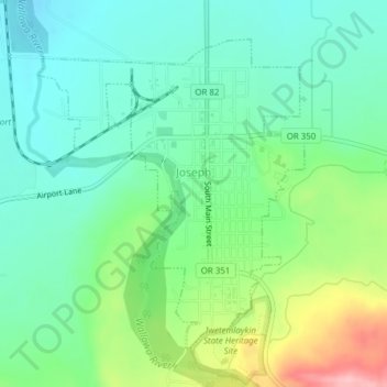
Name: Topografische Karte Joseph, Höhe, Relief.
Ort: Joseph, Wallowa County, Oregon, 97846, United States (45.33959 -117.24665 45.36118 -117.22024)
Durchschnittliche Höhe: 1.285 m
Minimale Höhe: 1.235 m
Maximale Höhe: 1.404 m
According to the United States Census Bureau, the city has a total area of 0.88 square miles (2.28 km2), all of it land.[11] The elevation is 4,190 feet (1,280 m) above sea level.
Andere topografische Karten
Klicken Sie auf eine Karte, um ihre Topografie, ihre Höhe und ihr Relief anzuzeigen.
Big Canyon Fish Weir
United States > Oregon > Wallowa County
Big Canyon Fish Weir, Wallowa County, Oregon, United States
Durchschnittliche Höhe: 944 m
Enterprise
United States > Oregon > Wallowa County
Enterprise, Wallowa County, Oregon, United States
Durchschnittliche Höhe: 1.162 m
Troy
United States > Oregon > Wallowa County
Troy, Wallowa County, Oregon, United States
Durchschnittliche Höhe: 711 m
Eagle Cap Wilderness
United States > Oregon > Wallowa County
Eagle Cap Wilderness, Wallowa County, Oregon, United States
Durchschnittliche Höhe: 1.629 m
Imnaha
United States > Oregon > Wallowa County > Imnaha
Imnaha, Wallowa County, Oregon, 97842, United States
Durchschnittliche Höhe: 861 m
Wallowa
United States > Oregon > Wallowa County > Wallowa
Wallowa, Wallowa County, Oregon, 97885, United States
Durchschnittliche Höhe: 937 m