
Topografische Karte Caldwell County
Interaktive Karte
Klicken Sie auf die Karte, um die Höhe anzuzeigen.
Über diese Karte
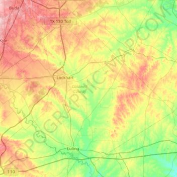
Name: Topografische Karte Caldwell County, Höhe, Relief.
Ort: Caldwell County, Texas, United States (29.63081 -97.89921 30.07138 -97.31577)
Durchschnittliche Höhe: 153 m
Minimale Höhe: 84 m
Maximale Höhe: 258 m
Andere topografische Karten
Klicken Sie auf eine Karte, um ihre Topografie, ihre Höhe und ihr Relief anzuzeigen.
McKinney Falls State Park
United States > Texas > Travis County > Austin
Durchschnittliche Höhe: 171 m
Choke Canyon State Park - Calliham Unit
United States > Texas > McMullen County > Calliham
Durchschnittliche Höhe: 67 m
Georgetown
United States > Texas > Georgetown
The city is located on the northeastern edge of Texas Hill Country. Portions of Georgetown are located on either side of the Balcones Escarpment, a fault line in which the areas roughly east of IH-35 are flat and characterized by having black, fertile soils of the Blackland Prairie, and the west side of the…
Durchschnittliche Höhe: 219 m
Emory Peak
United States > Texas > Brewster County
The peak can be reached by a moderate hike on a well-marked path across steep rocky terrain with an elevation gain of approximately 2,500 feet (760 m). The Emory Peak Trail is about 1.5 miles (2.4 km) long. The trail is reached by climbing the Pinnacles Trail 3.5 miles (5.6 km) from the Chisos Basin trailhead.…
Durchschnittliche Höhe: 2.061 m
Farnsworth
United States > Texas > Ochiltree County
Farnsworth is a census designated place in western Ochiltree County, Texas, United States. It lies at the intersection of State Highway 15 with FM376, southwest of the city of Perryton, the county seat of Ochiltree County. Its elevation is 2,995 feet (913 m). Although Farnsworth is unincorporated, it has a…
Durchschnittliche Höhe: 913 m
Jones Addition Colonia
United States > Texas > Cameron County > Rio Hondo
Durchschnittliche Höhe: 10 m
Sundance Square Plaza
United States > Texas > Tarrant County > Fort Worth
Durchschnittliche Höhe: 178 m
Lower Rio Grande Valley National Wildlife Refuge
United States > Texas > Starr County > Rio Grande City
Durchschnittliche Höhe: 50 m
San Luis Pass
United States > Texas > Galveston County > Galveston
Tides cause daily variations in topography, and occasionally, storms more drastically change the topography of the pass.
Durchschnittliche Höhe: 0 m
Altamira West Number 2 Colonia
United States > Texas > Hidalgo County > Edinburg
Durchschnittliche Höhe: 32 m
San Juan South Estates Colonia
United States > Texas > Hidalgo County > San Juan
Durchschnittliche Höhe: 34 m
Soil Conservation Service Site 12 Dam
United States > Texas > Williamson County > Type
Durchschnittliche Höhe: 173 m
Mission Hills Ranch
United States > Texas > Comal County > New Braunfels
Durchschnittliche Höhe: 287 m
Brazos Bend State Park
United States > Texas > Fort Bend County > Alvin
Brazos Bend State Park occupies land bordering the Brazos River and includes within its boundaries low-lying areas left over from the River's previous meanderings. Pre-Columbian inhabitants included a series of Native American groups, most notably the Karankawa. The land passed through a variety of landowners'…
Durchschnittliche Höhe: 17 m
Sierra Blanca
United States > Texas > Hudspeth County
Sierra Blanca is found in Far West Texas, a subdivision of West Texas, and is 4,520 feet (1,380 m) above sea level. The town is part of the Trans-Pecos region within the most mountainous and arid portion of Texas. The town is located in Hudspeth County, which is large and sparsely populated. Sierra Blanca…
Durchschnittliche Höhe: 1.391 m
Mc Arthur Park
United States > Texas > El Paso County > El Paso > Cielo Vista
Durchschnittliche Höhe: 1.199 m