
Topografische Karte Kota Kinabalu
Interaktive Karte
Klicken Sie auf die Karte, um die Höhe anzuzeigen.
Über diese Karte
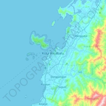
Name: Topografische Karte Kota Kinabalu, Höhe, Relief.
Ort: Kota Kinabalu, West Coast Division, Sabah, 88000, Malaysia (5.81801 115.91290 6.13801 116.23290)
Durchschnittliche Höhe: 86 m
Minimale Höhe: -2 m
Maximale Höhe: 1.093 m
Andere topografische Karten
Klicken Sie auf eine Karte, um ihre Topografie, ihre Höhe und ihr Relief anzuzeigen.
Ranau
Ranau is noted for its hilly geographical structure and is the largest producer of highland vegetables in the state of Sabah. Tourism and highland agriculture are the major industries, as the district is at an altitude of 1,176 m above sea level. Its many tourist destinations attracted half a million tourists…
Durchschnittliche Höhe: 689 m
Sipitang
Sipitang district is located within a national and international route. Southern Sabah Federal Route 1 of the Pan Borneo Highway passes through this district, hence it can be reached from Beaufort from the north, Tenom from the east and Lawas, Sarawak from southwest. At the same time, the coastline stretches…
Durchschnittliche Höhe: 716 m
Ranau
Ranau is noted for its hilly geographical structure and is the largest producer of highland vegetables in the state of Sabah. Tourism and highland agriculture are the major industries, as the district is at an altitude of 1,176 m above sea level. Its many tourist destinations attracted half a million tourists…
Durchschnittliche Höhe: 689 m
Tasik Kompleks Sukan Sandakan
Malaysia > Sabah > Sandakan District > Sandakan
Durchschnittliche Höhe: 25 m
Kinabalu Park
Malaysia > Sabah > Ranau > Tinompok
The park headquarters is 88 kilometres away from the city of Kota Kinabalu. There are sealed roads leading towards the park headquarters from other parts of Sabah. It is situated on the southern boundary of Kinabalu Park, at an elevation of 1,563 m (5,128 ft).
Durchschnittliche Höhe: 2.063 m
Banggi Island
Banggi Island (Malay: Pulau Banggi) is located within the Kudat Division of Sabah in Malaysia. With an area of 440.7 square kilometres, it is the largest island in Malaysia followed by Bruit Island, Langkawi Island and Penang Island. It is located off the northern coast of Sabah near Marudu Bay. The highest…
Durchschnittliche Höhe: 21 m
Gaya Island
Malaysia > Sabah > Kota Kinabalu
Gaya Island (Malay: Pulau Gaya) is a sizeable Malaysian island of 1,465 ha, just 10 minutes off Kota Kinabalu, Sabah and forms part of the Tunku Abdul Rahman National Park. Gaya Island derived its name from the word "Gayo" which means big in both the Kadazandusun and Bajau languages and occupies an area of 15…
Durchschnittliche Höhe: 34 m
Banggi Island
Banggi Island (Malay: Pulau Banggi) is located within the Kudat Division of Sabah in Malaysia. With an area of 440.7 square kilometres, it is the largest island in Malaysia followed by Bruit Island, Langkawi Island and Penang Island. It is located off the northern coast of Sabah near Marudu Bay. The highest…
Durchschnittliche Höhe: 21 m