
Topografische Karte Capital Dome
Interaktive Karte
Klicken Sie auf die Karte, um die Höhe anzuzeigen.
Über diese Karte
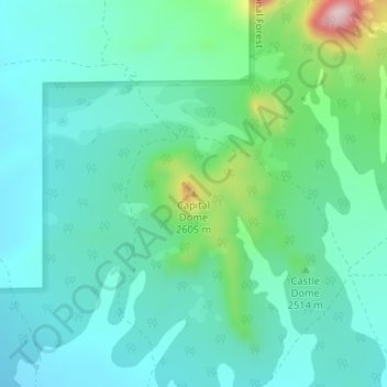
Name: Topografische Karte Capital Dome, Höhe, Relief.
Ort: Capital Dome, Catron County, New Mexico, United States (34.30973 -108.05955 34.30983 -108.05945)
Durchschnittliche Höhe: 2.459 m
Minimale Höhe: 2.395 m
Maximale Höhe: 2.694 m
Andere topografische Karten
Klicken Sie auf eine Karte, um ihre Topografie, ihre Höhe und ihr Relief anzuzeigen.
Prairie Lake
United States > New Mexico > Catron County
Prairie Lake, Catron County, New Mexico, United States
Durchschnittliche Höhe: 2.342 m
San Francisco
United States > New Mexico > Catron County
San Francisco, Catron County, New Mexico, United States
Durchschnittliche Höhe: 2.440 m
Quemado
United States > New Mexico > Catron County
Quemado, Catron County, New Mexico, United States
Durchschnittliche Höhe: 2.113 m
Alma
United States > New Mexico > Catron County
Alma, Catron County, New Mexico, United States
Durchschnittliche Höhe: 1.535 m
Cruzville
United States > New Mexico > Catron County
Cruzville, Catron County, New Mexico, United States
Durchschnittliche Höhe: 1.975 m
Reserve
United States > New Mexico > Catron County
Reserve, Catron County, New Mexico, United States
Durchschnittliche Höhe: 1.780 m
Datil
United States > New Mexico > Catron County
Datil, Catron County, New Mexico, United States
Durchschnittliche Höhe: 2.279 m
Gila Wilderness
United States > New Mexico > Catron County
Gila Wilderness, Catron County, New Mexico, United States
Durchschnittliche Höhe: 2.085 m
Pie Town
United States > New Mexico > Catron County
Pie Town, Catron County, New Mexico, 87827, United States
Durchschnittliche Höhe: 2.352 m
San Francisco Mountains
United States > New Mexico > Catron County
San Francisco Mountains, Catron County, New Mexico, United States
Durchschnittliche Höhe: 2.541 m