
Topografische Karte Gila Wilderness
Interaktive Karte
Klicken Sie auf die Karte, um die Höhe anzuzeigen.
Über diese Karte
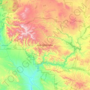
Name: Topografische Karte Gila Wilderness, Höhe, Relief.
Ort: Gila Wilderness, Catron County, New Mexico, United States (33.00793 -108.81918 33.41853 -108.00968)
Durchschnittliche Höhe: 2.085 m
Minimale Höhe: 1.340 m
Maximale Höhe: 3.327 m
The Gila Wilderness is located in southwest New Mexico, north of Silver City and east of Reserve. It contains the West Fork, Middle Fork and much of the East Fork of the Gila River; riverside elevations of around 4,850 feet (1,480 m) are the lowest in the wilderness. The Mogollon Mountains traverse an arc across the wilderness. The tallest peak within this range, Whitewater Baldy at 10,895 ft (3,321 m), is in the northwest part of the wilderness along with several other summits more than 10,000 ft (3,048 m) high. At the northeast corner is prominent Black Mountain rising to 9,287 ft (2,831 m). The Gila Cliff Dwellings National Monument is adjacent to the wilderness.
Andere topografische Karten
Klicken Sie auf eine Karte, um ihre Topografie, ihre Höhe und ihr Relief anzuzeigen.
Prairie Lake
United States > New Mexico > Catron County
Prairie Lake, Catron County, New Mexico, United States
Durchschnittliche Höhe: 2.342 m
San Francisco
United States > New Mexico > Catron County
San Francisco, Catron County, New Mexico, United States
Durchschnittliche Höhe: 2.440 m
Quemado
United States > New Mexico > Catron County
Quemado, Catron County, New Mexico, United States
Durchschnittliche Höhe: 2.113 m
Alma
United States > New Mexico > Catron County
Alma, Catron County, New Mexico, United States
Durchschnittliche Höhe: 1.535 m
Capital Dome
United States > New Mexico > Catron County
Capital Dome, Catron County, New Mexico, United States
Durchschnittliche Höhe: 2.459 m
Cruzville
United States > New Mexico > Catron County
Cruzville, Catron County, New Mexico, United States
Durchschnittliche Höhe: 1.975 m
Reserve
United States > New Mexico > Catron County
Reserve, Catron County, New Mexico, United States
Durchschnittliche Höhe: 1.780 m
Datil
United States > New Mexico > Catron County
Datil, Catron County, New Mexico, United States
Durchschnittliche Höhe: 2.279 m
Pie Town
United States > New Mexico > Catron County
Pie Town, Catron County, New Mexico, 87827, United States
Durchschnittliche Höhe: 2.352 m
San Francisco Mountains
United States > New Mexico > Catron County
San Francisco Mountains, Catron County, New Mexico, United States
Durchschnittliche Höhe: 2.541 m