
Topografische Karte Lyndhurst
Klicken Sie auf die Karte, um die Höhe anzuzeigen.
Über diese Karte
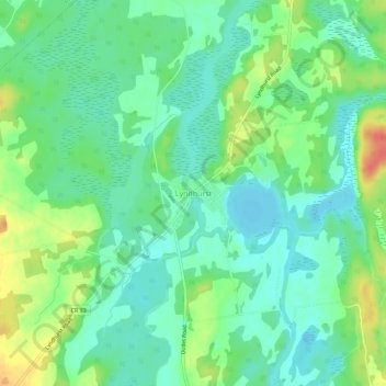
Name: Topografische Karte Lyndhurst, Höhe, Relief.
Durchschnittliche Höhe: 98 m
Minimale Höhe: 81 m
Maximale Höhe: 130 m
Andere topografische Karten
Klicken Sie auf eine Karte, um ihre Topografie, ihre Höhe und ihr Relief anzuzeigen.
Charleston Lake
Canada > Ontario > Leeds and Grenville Counties > Leeds and the Thousand Islands > Outlet
Durchschnittliche Höhe: 103 m
Thousand Islands National Park
Canada > Ontario > Leeds and Grenville Counties > Leeds and the Thousand Islands > Rockport
Durchschnittliche Höhe: 116 m
Gananoque Lake
Canada > Ontario > Leeds and Grenville Counties > Leeds and the Thousand Islands
Durchschnittliche Höhe: 92 m
Leeds
Canada > Ontario > Leeds and Grenville Counties > Leeds and the Thousand Islands
Durchschnittliche Höhe: 104 m
Leeds
Canada > Ontario > Leeds and Grenville Counties > Leeds and the Thousand Islands
Durchschnittliche Höhe: 104 m
Codfish Island
Canada > Ontario > Leeds and Grenville Counties > Leeds and the Thousand Islands
Durchschnittliche Höhe: 79 m
Why Island
Canada > Ontario > Leeds and Grenville Counties > Leeds and the Thousand Islands
Durchschnittliche Höhe: 92 m