
Topografische Karte Leeds
Klicken Sie auf die Karte, um die Höhe anzuzeigen.
Über diese Karte
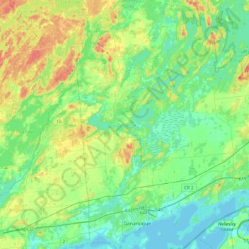
Name: Topografische Karte Leeds, Höhe, Relief.
Durchschnittliche Höhe: 104 m
Minimale Höhe: 73 m
Maximale Höhe: 185 m
Andere topografische Karten
Klicken Sie auf eine Karte, um ihre Topografie, ihre Höhe und ihr Relief anzuzeigen.
Lyndhurst
Canada > Ontario > Leeds and Grenville Counties > Leeds and the Thousand Islands
Durchschnittliche Höhe: 98 m
Seeleys Bay
Canada > Ontario > Leeds and Grenville Counties > Leeds and the Thousand Islands > Seeley's Bay
Durchschnittliche Höhe: 105 m
Waterton
Canada > Ontario > Leeds and Grenville Counties > Leeds and the Thousand Islands > Waterton
Durchschnittliche Höhe: 97 m
Lansdowne
Canada > Ontario > Leeds and Grenville Counties > Leeds and the Thousand Islands
Durchschnittliche Höhe: 101 m
Junetown
Canada > Ontario > Leeds and Grenville Counties > Leeds and the Thousand Islands
Durchschnittliche Höhe: 110 m
Seeley's Bay
Canada > Ontario > Leeds and Grenville Counties > Leeds and the Thousand Islands
Durchschnittliche Höhe: 106 m
Outlet
Canada > Ontario > Leeds and Grenville Counties > Leeds and the Thousand Islands
Durchschnittliche Höhe: 97 m
Quabbin
Canada > Ontario > Leeds and Grenville Counties > Leeds and the Thousand Islands
Durchschnittliche Höhe: 97 m
Rochester Bay
Canada > Ontario > Leeds and Grenville Counties > Leeds and the Thousand Islands
Durchschnittliche Höhe: 74 m
Codfish Island
Canada > Ontario > Leeds and Grenville Counties > Leeds and the Thousand Islands
Durchschnittliche Höhe: 79 m
Why Island
Canada > Ontario > Leeds and Grenville Counties > Leeds and the Thousand Islands
Durchschnittliche Höhe: 92 m
Seeleys Bay
Canada > Ontario > Leeds and Grenville Counties > Leeds and the Thousand Islands > Seeley's Bay
Durchschnittliche Höhe: 105 m
Outlet
Canada > Ontario > Leeds and Grenville Counties > Leeds and the Thousand Islands
Durchschnittliche Höhe: 97 m