
Topografische Karte Delta
Interaktive Karte
Klicken Sie auf die Karte, um die Höhe anzuzeigen.
Über diese Karte
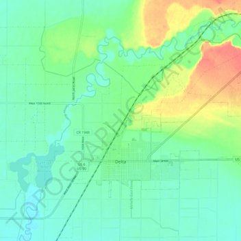
Name: Topografische Karte Delta, Höhe, Relief.
Ort: Delta, Millard County, Utah, United States (39.33856 -112.61453 39.39694 -112.49604)
Durchschnittliche Höhe: 1.417 m
Minimale Höhe: 1.401 m
Maximale Höhe: 1.453 m
Delta experiences a cold semi-arid climate (Köppen BSk) with hot summers and cold winters. Because of Delta's altitude and aridity, temperatures drop quickly after sunset, especially in the summer. Winters are cold. Daytime highs in the winter are usually above freezing, but nighttime lows drop well below freezing, occasionally falling below 0 °F or −17.8 °C. Delta's climate is similar to that of Salt Lake City, but much more arid.
Andere topografische Karten
Klicken Sie auf eine Karte, um ihre Topografie, ihre Höhe und ihr Relief anzuzeigen.
Lynndyl
United States > Utah > Millard County
Lynndyl, Millard County, Utah, 84640, United States
Durchschnittliche Höhe: 1.451 m
Fillmore
United States > Utah > Millard County
Fillmore, Millard County, Utah, 84631, United States
Durchschnittliche Höhe: 1.584 m
West Desert Sinkhole
United States > Utah > Millard County
West Desert Sinkhole, Millard County, Utah, United States
Durchschnittliche Höhe: 1.707 m