
Topografische Karte Fillmore
Interaktive Karte
Klicken Sie auf die Karte, um die Höhe anzuzeigen.
Über diese Karte
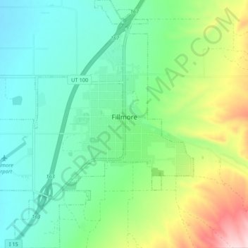
Name: Topografische Karte Fillmore, Höhe, Relief.
Ort: Fillmore, Millard County, Utah, 84631, United States (38.93524 -112.37219 38.99876 -112.30076)
Durchschnittliche Höhe: 1.584 m
Minimale Höhe: 1.493 m
Maximale Höhe: 1.809 m
Fillmore is located at an elevation of 5,135 feet (1,565 m) in elevation. It lies in the Pahvant Valley, near the base of the Pahvant Mountain Range.
Andere topografische Karten
Klicken Sie auf eine Karte, um ihre Topografie, ihre Höhe und ihr Relief anzuzeigen.
Lynndyl
United States > Utah > Millard County
Lynndyl, Millard County, Utah, 84640, United States
Durchschnittliche Höhe: 1.451 m
Delta
United States > Utah > Millard County
Delta, Millard County, Utah, United States
Durchschnittliche Höhe: 1.417 m
West Desert Sinkhole
United States > Utah > Millard County
West Desert Sinkhole, Millard County, Utah, United States
Durchschnittliche Höhe: 1.707 m