
Topografische Karte Mount Whitney
Interaktive Karte
Klicken Sie auf die Karte, um die Höhe anzuzeigen.
Über diese Karte
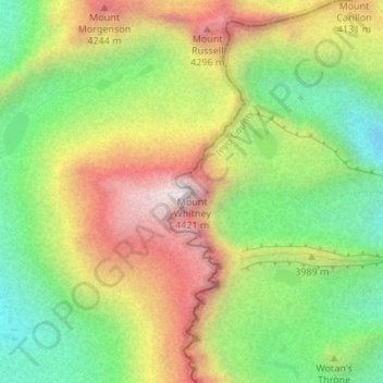
Name: Topografische Karte Mount Whitney, Höhe, Relief.
Ort: Mount Whitney, Inyo County, California, United States (36.57854 -118.29219 36.57864 -118.29209)
Durchschnittliche Höhe: 3.903 m
Minimale Höhe: 3.475 m
Maximale Höhe: 4.415 m
Mount Whitney (Paiute: Tumanguya; Too-man-i-goo-yah) is the highest mountain in the contiguous United States and the Sierra Nevada, with an elevation of 14,505 feet (4,421 m). It is in East–Central California, on the boundary between California's Inyo and Tulare counties, 84.6 miles (136.2 km) west-northwest of North America's lowest point, Badwater Basin in Death Valley National Park, at 282 ft (86 m) below sea level. The mountain's west slope is in Sequoia National Park and the summit is the southern terminus of the John Muir Trail, which runs 211.9 mi (341.0 km) from Happy Isles in Yosemite Valley. The eastern slopes are in Inyo National Forest in Inyo County.
Andere topografische Karten
Klicken Sie auf eine Karte, um ihre Topografie, ihre Höhe und ihr Relief anzuzeigen.
Mount Starr
United States > California > Inyo County
Mount Starr, Inyo County, California, United States
Durchschnittliche Höhe: 3.509 m
Kearsarge Peak
United States > California > Inyo County
Kearsarge Peak, Inyo County, California, United States
Durchschnittliche Höhe: 3.394 m
Badwater Basin
United States > California > Inyo County
Badwater Basin, Inyo County, California, United States
Durchschnittliche Höhe: 152 m
Mount LeConte
United States > California > Inyo County
Mount LeConte, Inyo County, California, United States
Durchschnittliche Höhe: 3.789 m
Kearsarge
United States > California > Inyo County
Kearsarge, Inyo County, California, United States
Durchschnittliche Höhe: 1.159 m
Independence
United States > California > Inyo County
Independence, Inyo County, CAL Fire Southern Region, California, 93526, United States
Durchschnittliche Höhe: 1.210 m
Death Valley Junction
United States > California > Inyo County
Death Valley Junction, Inyo County, California, United States
Durchschnittliche Höhe: 627 m
Dante's View
United States > California > Inyo County
Dante's View, Inyo County, California, United States
Durchschnittliche Höhe: 1.403 m
Lake Sabrina
United States > California > Inyo County
Lake Sabrina, Inyo County, California, United States
Durchschnittliche Höhe: 3.033 m
Tecopa
United States > California > Inyo County > Tecopa
Tecopa, Inyo County, California, United States
Durchschnittliche Höhe: 508 m
Bishop
United States > California > Inyo County
Bishop, Inyo County, California, United States
Durchschnittliche Höhe: 1.265 m
Owens River
United States > California > Inyo County
Owens River, Inyo County, California, United States
Durchschnittliche Höhe: 1.183 m
Lone Pine
United States > California > Inyo County
Lone Pine, Inyo County, CAL Fire Southern Region, California, 93545, United States
Durchschnittliche Höhe: 1.298 m
Crater
United States > California > Inyo County
Crater, Inyo County, California, United States
Durchschnittliche Höhe: 1.657 m
Furnace Creek
United States > California > Inyo County
Furnace Creek, Inyo County, California, 92328, United States
Durchschnittliche Höhe: -27 m