
Topografische Karte Badwater Basin
Interaktive Karte
Klicken Sie auf die Karte, um die Höhe anzuzeigen.
Über diese Karte
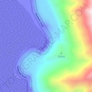
Name: Topografische Karte Badwater Basin, Höhe, Relief.
Ort: Badwater Basin, Inyo County, California, United States (36.22999 -116.76767 36.23055 -116.76716)
Durchschnittliche Höhe: 152 m
Minimale Höhe: -84 m
Maximale Höhe: 914 m
The pool is not the lowest point of the basin: the lowest point (which is only slightly lower) is several miles to the west and varies in position, depending on rainfall and evaporation patterns. The salt flats are hazardous to traverse (in many cases being only a thin white crust over mud), and so the sign marking the low point is at the pool instead. The basin was considered the lowest elevation in the Western Hemisphere until the discovery of Laguna del Carbón in Argentina at −344 ft (−105 m).
Andere topografische Karten
Klicken Sie auf eine Karte, um ihre Topografie, ihre Höhe und ihr Relief anzuzeigen.
Mount LeConte
United States > California > Inyo County
Mount LeConte, Inyo County, California, United States
Durchschnittliche Höhe: 3.789 m
Kearsarge
United States > California > Inyo County
Kearsarge, Inyo County, California, United States
Durchschnittliche Höhe: 1.159 m
Independence
United States > California > Inyo County
Independence, Inyo County, CAL Fire Southern Region, California, 93526, United States
Durchschnittliche Höhe: 1.210 m
Death Valley Junction
United States > California > Inyo County
Death Valley Junction, Inyo County, California, United States
Durchschnittliche Höhe: 627 m
Dante's View
United States > California > Inyo County
Dante's View, Inyo County, California, United States
Durchschnittliche Höhe: 1.403 m
Lake Sabrina
United States > California > Inyo County
Lake Sabrina, Inyo County, California, United States
Durchschnittliche Höhe: 3.033 m
Tecopa
United States > California > Inyo County > Tecopa
Tecopa, Inyo County, California, United States
Durchschnittliche Höhe: 508 m
Mount Whitney
United States > California > Inyo County
Mount Whitney, Inyo County, CAL Fire Southern Region, California, United States
Durchschnittliche Höhe: 3.903 m
Bishop
United States > California > Inyo County
Bishop, Inyo County, California, United States
Durchschnittliche Höhe: 1.265 m
Owens River
United States > California > Inyo County
Owens River, Inyo County, California, United States
Durchschnittliche Höhe: 1.183 m
Lone Pine
United States > California > Inyo County
Lone Pine, Inyo County, CAL Fire Southern Region, California, 93545, United States
Durchschnittliche Höhe: 1.298 m
Furnace Creek
United States > California > Inyo County
Furnace Creek, Inyo County, California, 92328, United States
Durchschnittliche Höhe: -27 m
Crater
United States > California > Inyo County
Crater, Inyo County, California, United States
Durchschnittliche Höhe: 1.657 m