
Topografische Karte Białka Tatrzańska
Interaktive Karte
Klicken Sie auf die Karte, um die Höhe anzuzeigen.
Über diese Karte
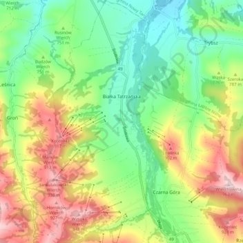
Name: Topografische Karte Białka Tatrzańska, Höhe, Relief.
Durchschnittliche Höhe: 766 m
Minimale Höhe: 637 m
Maximale Höhe: 959 m
Andere topografische Karten
Klicken Sie auf eine Karte, um ihre Topografie, ihre Höhe und ihr Relief anzuzeigen.
Małe Ciche
Poland > Lesser Poland Voivodeship > Tatra County
Małe Ciche, gmina Poronin, Tatra County, Lesser Poland Voivodeship, Poland
Durchschnittliche Höhe: 1.012 m
Zakopane
Poland > Lesser Poland Voivodeship > Tatra County
Zakopane, Tatra County, Lesser Poland Voivodeship, Poland
Durchschnittliche Höhe: 1.199 m
Stasindowie
Poland > Lesser Poland Voivodeship > Tatra County > Gliczarów Górny
Stasindowie, Gliczarów Górny, gmina Biały Dunajec, Tatra County, Lesser Poland Voivodeship, 34-531, Poland
Durchschnittliche Höhe: 894 m
Morskie Oko
Poland > Lesser Poland Voivodeship > Tatra County > Brzegi
Morskie Oko, Brzegi, gmina Bukowina Tatrzańska, Tatra County, Lesser Poland Voivodeship, Poland
Durchschnittliche Höhe: 1.749 m
Kaniówka
Poland > Lesser Poland Voivodeship > Tatra County > Białka Tatrzańska
Kaniówka, Białka Tatrzańska, gmina Bukowina Tatrzańska, Tatra County, Lesser Poland Voivodeship, 34-405, Poland
Durchschnittliche Höhe: 794 m
Tatry
Poland > Lesser Poland Voivodeship > Tatra County > Zakopane
Tatry, Zakopane, Tatra County, Lesser Poland Voivodeship, Poland
Durchschnittliche Höhe: 1.647 m
Czarny Potok
Poland > Lesser Poland Voivodeship > Tatra County > Zakopane
Czarny Potok, Osiedle Kasprusie, Zakopane, Tatra County, Lesser Poland Voivodeship, 34-500, Poland
Durchschnittliche Höhe: 869 m
Wielki Giewont
Poland > Lesser Poland Voivodeship > Tatra County > Zakopane
Wielki Giewont, Zakopane, Tatra County, Lesser Poland Voivodeship, Poland
Durchschnittliche Höhe: 1.478 m
Zakopane
Poland > Lesser Poland Voivodeship > Tatra County
Zakopane, Tatra County, Lesser Poland Voivodeship, Poland
Durchschnittliche Höhe: 1.180 m
Dzianisz
Poland > Lesser Poland Voivodeship > Tatra County > Dzianisz
Dzianisz, gmina Kościelisko, Tatra County, Lesser Poland Voivodeship, 34-514, Poland
Durchschnittliche Höhe: 930 m
Bukowina Tatrzańska
Poland > Lesser Poland Voivodeship > Tatra County
Bukowina Tatrzańska, gmina Bukowina Tatrzańska, Tatra County, Lesser Poland Voivodeship, 34-530, Poland
Durchschnittliche Höhe: 886 m
Jurgów
Poland > Lesser Poland Voivodeship > Tatra County
Jurgów, gmina Bukowina Tatrzańska, Tatra County, Lesser Poland Voivodeship, 34-532, Poland
Durchschnittliche Höhe: 888 m
Biały Dunajec
Poland > Lesser Poland Voivodeship > Tatra County
Biały Dunajec, gmina Biały Dunajec, Tatra County, Lesser Poland Voivodeship, 34-425, Poland
Durchschnittliche Höhe: 816 m