
Topografische Karte Zakopane
Interaktive Karte
Klicken Sie auf die Karte, um die Höhe anzuzeigen.
Über diese Karte
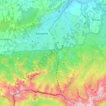
Name: Topografische Karte Zakopane, Höhe, Relief.
Ort: Zakopane, Tatra County, Lesser Poland Voivodeship, Poland (49.21835 19.90039 49.33317 20.04316)
Durchschnittliche Höhe: 1.199 m
Minimale Höhe: 742 m
Maximale Höhe: 2.248 m
Zakopane has a humid continental climate (Köppen climate classification: Dfb), with the main factor behind its relative coldness compared to the rest of Poland is its altitude. In general, the temperature tends to fall with altitude, therefore Zakopane is almost 3 °C (5.4 °F) colder than northern Kraków, which is more than 600 m (2,000 ft) lower than Zakopane. With higher altitudes, the climate gets even colder, therefore, on the top of Kasprowy Wierch (1,987 m (6,519 ft) above sea level), the climate is tundra-like (Köppen: ET). The tree line is located at about 1,500 m (4,900 ft) above sea level in the Tatra Mountains.
Andere topografische Karten
Klicken Sie auf eine Karte, um ihre Topografie, ihre Höhe und ihr Relief anzuzeigen.
Małe Ciche
Poland > Lesser Poland Voivodeship > Tatra County
Małe Ciche, gmina Poronin, Tatra County, Lesser Poland Voivodeship, Poland
Durchschnittliche Höhe: 1.012 m
Stasindowie
Poland > Lesser Poland Voivodeship > Tatra County > Gliczarów Górny
Stasindowie, Gliczarów Górny, gmina Biały Dunajec, Tatra County, Lesser Poland Voivodeship, 34-531, Poland
Durchschnittliche Höhe: 894 m
Morskie Oko
Poland > Lesser Poland Voivodeship > Tatra County > Brzegi
Morskie Oko, Brzegi, gmina Bukowina Tatrzańska, Tatra County, Lesser Poland Voivodeship, Poland
Durchschnittliche Höhe: 1.749 m
Białka Tatrzańska
Poland > Lesser Poland Voivodeship > Tatra County
Białka Tatrzańska, gmina Bukowina Tatrzańska, Tatra County, Lesser Poland Voivodeship, 34-405, Poland
Durchschnittliche Höhe: 766 m
Kaniówka
Poland > Lesser Poland Voivodeship > Tatra County > Białka Tatrzańska
Kaniówka, Białka Tatrzańska, gmina Bukowina Tatrzańska, Tatra County, Lesser Poland Voivodeship, 34-405, Poland
Durchschnittliche Höhe: 794 m
Tatry
Poland > Lesser Poland Voivodeship > Tatra County > Zakopane
Tatry, Zakopane, Tatra County, Lesser Poland Voivodeship, Poland
Durchschnittliche Höhe: 1.647 m
Czarny Potok
Poland > Lesser Poland Voivodeship > Tatra County > Zakopane
Czarny Potok, Osiedle Kasprusie, Zakopane, Tatra County, Lesser Poland Voivodeship, 34-500, Poland
Durchschnittliche Höhe: 869 m
Wielki Giewont
Poland > Lesser Poland Voivodeship > Tatra County > Zakopane
Wielki Giewont, Zakopane, Tatra County, Lesser Poland Voivodeship, Poland
Durchschnittliche Höhe: 1.478 m
Zakopane
Poland > Lesser Poland Voivodeship > Tatra County
Zakopane, Tatra County, Lesser Poland Voivodeship, Poland
Durchschnittliche Höhe: 1.180 m
Dzianisz
Poland > Lesser Poland Voivodeship > Tatra County > Dzianisz
Dzianisz, gmina Kościelisko, Tatra County, Lesser Poland Voivodeship, 34-514, Poland
Durchschnittliche Höhe: 930 m
Bukowina Tatrzańska
Poland > Lesser Poland Voivodeship > Tatra County
Bukowina Tatrzańska, gmina Bukowina Tatrzańska, Tatra County, Lesser Poland Voivodeship, 34-530, Poland
Durchschnittliche Höhe: 886 m
Jurgów
Poland > Lesser Poland Voivodeship > Tatra County
Jurgów, gmina Bukowina Tatrzańska, Tatra County, Lesser Poland Voivodeship, 34-532, Poland
Durchschnittliche Höhe: 888 m
Biały Dunajec
Poland > Lesser Poland Voivodeship > Tatra County
Biały Dunajec, gmina Biały Dunajec, Tatra County, Lesser Poland Voivodeship, 34-425, Poland
Durchschnittliche Höhe: 816 m