
Topografische Karte Rhode Island
Interaktive Karte
Klicken Sie auf die Karte, um die Höhe anzuzeigen.
Über diese Karte
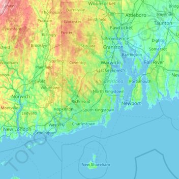
Name: Topografische Karte Rhode Island, Höhe, Relief.
Ort: Rhode Island, United States (41.09583 -71.90743 42.01894 -71.08857)
Durchschnittliche Höhe: 53 m
Minimale Höhe: -8 m
Maximale Höhe: 393 m
Rhode Island covers an area of 1,214 square miles (3,144 km2) within the New England region of the Northeastern United States and is bordered on the north and east by Massachusetts, on the west by Connecticut, and on the south by Rhode Island Sound and the Atlantic Ocean. It shares a narrow maritime border with New York State between Block Island and Long Island. The state's mean elevation is 200 feet (61 m). It is only 37 miles (60 km) wide and 48 miles (77 km) long, yet the state has a tidal shoreline on Narragansett Bay and the Atlantic Ocean of 384 miles (618 km).
Andere topografische Karten
Klicken Sie auf eine Karte, um ihre Topografie, ihre Höhe und ihr Relief anzuzeigen.
Sacramento
United States > California > Sacramento County
Sacramento, Sacramento County, California, United States
Durchschnittliche Höhe: 10 m
Los Angeles
Los Angeles, California, United States
Durchschnittliche Höhe: 241 m
New Orleans
United States > Louisiana > Orleans Parish
New Orleans, Orleans Parish, Louisiana, United States
Durchschnittliche Höhe: 1 m
Central Park
United States > New York > New York County > New York
Central Park, New York County, New York, United States
Durchschnittliche Höhe: 26 m
Boulder
United States > Colorado > Boulder County
Boulder, Boulder County, Colorado, United States
Durchschnittliche Höhe: 1.785 m
Norfolk
United States > Virginia > Norfolk
Norfolk, Virginia, 23510, United States
Durchschnittliche Höhe: 4 m
Houston
United States > Texas > Harris County
Houston, Harris County, Texas, United States
Durchschnittliche Höhe: 25 m
Broward County
Broward County, Florida, United States
Durchschnittliche Höhe: 5 m
Indianapolis
United States > Indiana > Indianapolis
Indianapolis, Marion County, Indiana, 46204, United States
Durchschnittliche Höhe: 241 m
Madison
United States > Wisconsin > Dane County
Madison, Dane County, Wisconsin, United States
Durchschnittliche Höhe: 284 m
Highlands Ranch
United States > Colorado > Douglas County
Highlands Ranch, Douglas County, Colorado, 80126, United States
Durchschnittliche Höhe: 1.758 m
Fort Lauderdale
United States > Florida > Broward County
Fort Lauderdale, Broward County, Florida, United States
Durchschnittliche Höhe: 5 m
Blue Ridge Parkway
United States > North Carolina > Watauga County
Blue Ridge Parkway, Watauga County, North Carolina, United States
Durchschnittliche Höhe: 505 m
Ruidoso
United States > New Mexico > Lincoln County
Ruidoso, Lincoln County, New Mexico, United States
Durchschnittliche Höhe: 2.287 m
Brooklyn
United States > New York > New York
Brooklyn, Kings County, New York, United States
Durchschnittliche Höhe: 9 m
Salt Lake County
Salt Lake County, Utah, United States
Durchschnittliche Höhe: 1.811 m
Kitsap County
Kitsap County, Washington, United States
Durchschnittliche Höhe: 138 m
Hillsborough County
Hillsborough County, Florida, United States
Durchschnittliche Höhe: 20 m
Fresno
United States > California > Fresno County
Fresno, Fresno County, California, United States
Durchschnittliche Höhe: 98 m
Cedar City
United States > Utah > Iron County
Cedar City, Iron County, Utah, United States
Durchschnittliche Höhe: 1.975 m