
Topografische Karte Massachusetts
Interaktive Karte
Klicken Sie auf die Karte, um die Höhe anzuzeigen.
Über diese Karte
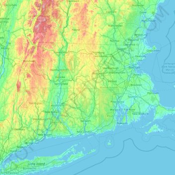
Name: Topografische Karte Massachusetts, Höhe, Relief.
Ort: Massachusetts, United States (41.18886 -73.50821 42.88678 -69.86010)
Durchschnittliche Höhe: 128 m
Minimale Höhe: -7 m
Maximale Höhe: 1.159 m
Despite its small size, Massachusetts features numerous topographically distinctive regions. The large coastal plain of the Atlantic Ocean in the eastern section of the state contains Greater Boston, along with most of the state's population, as well as the distinctive Cape Cod peninsula. To the west lies the hilly, rural region of Central Massachusetts, and beyond that, the Connecticut River Valley. Along the western border of Western Massachusetts lies the highest elevated part of the state, the Berkshires, forming a portion of the northern terminus of the Appalachian Mountains.
Andere topografische Karten
Klicken Sie auf eine Karte, um ihre Topografie, ihre Höhe und ihr Relief anzuzeigen.
Jacksonville
United States > Florida > Duval County
Jacksonville, Duval County, Florida, United States
Durchschnittliche Höhe: 10 m
Los Angeles
Los Angeles, California, United States
Durchschnittliche Höhe: 241 m
Lancaster County
Lancaster County, Pennsylvania, United States
Durchschnittliche Höhe: 158 m
Manhattan
United States > New York > New York County > New York
Manhattan, New York County, New York, United States
Durchschnittliche Höhe: 16 m
Albuquerque
United States > New Mexico > Bernalillo County
Albuquerque, Bernalillo County, New Mexico, United States
Durchschnittliche Höhe: 1.688 m
Provo
United States > Utah > Utah County
Provo, Utah County, Utah, United States
Durchschnittliche Höhe: 1.728 m
Laurel
United States > Ohio > Clermont County
Laurel, Monroe Township, Clermont County, Ohio, 45153, United States
Durchschnittliche Höhe: 252 m
Coeur d'Alene
United States > Idaho > Kootenai County
Coeur d'Alene, Kootenai County, Idaho, United States
Durchschnittliche Höhe: 719 m
King County
King County, Washington, United States
Durchschnittliche Höhe: 569 m
Tampa
United States > Florida > Hillsborough County
Tampa, Hillsborough County, Florida, United States
Durchschnittliche Höhe: 11 m
South Venice
United States > Florida > Sarasota County
South Venice, Sarasota County, Florida, United States
Durchschnittliche Höhe: 4 m
Larimer County
Larimer County, Colorado, United States
Durchschnittliche Höhe: 2.363 m
Fort Bend County
Fort Bend County, Texas, United States
Durchschnittliche Höhe: 28 m
Brooklyn
United States > New York > New York
Brooklyn, Kings County, New York, United States
Durchschnittliche Höhe: 9 m
Lapeer County
Lapeer County, Michigan, United States
Durchschnittliche Höhe: 261 m
Hudson River
Hudson River, New Jersey, 12834:12871, United States
Durchschnittliche Höhe: 297 m
Houston
United States > Texas > Harris County
Houston, Harris County, Texas, United States
Durchschnittliche Höhe: 25 m
Santa Cruz
United States > California > Santa Cruz County
Santa Cruz, Santa Cruz County, California, United States
Durchschnittliche Höhe: 89 m
Blue Ridge Parkway
United States > North Carolina > Watauga County
Blue Ridge Parkway, Watauga County, North Carolina, United States
Durchschnittliche Höhe: 505 m
Spartanburg County
United States > South Carolina
Spartanburg County, South Carolina, United States
Durchschnittliche Höhe: 239 m
Salt Lake County
Salt Lake County, Utah, United States
Durchschnittliche Höhe: 1.811 m