
Topografische Karte Mississippi
Interaktive Karte
Klicken Sie auf die Karte, um die Höhe anzuzeigen.
Über diese Karte
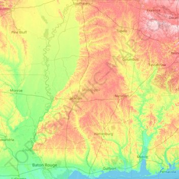
Name: Topografische Karte Mississippi, Höhe, Relief.
Ort: Mississippi, United States (30.14368 -91.65501 34.99602 -88.09779)
Durchschnittliche Höhe: 74 m
Minimale Höhe: -3 m
Maximale Höhe: 334 m
Mississippi is entirely composed of lowlands, the highest point being Woodall Mountain, at 807 ft (246 m) above sea level, in the northeastern part of the state. The lowest point is sea level at the Gulf Coast. The state's mean elevation is 300 ft (91 m) above sea level.
Andere topografische Karten
Klicken Sie auf eine Karte, um ihre Topografie, ihre Höhe und ihr Relief anzuzeigen.
Los Angeles
Los Angeles, California, United States
Durchschnittliche Höhe: 241 m
Broward County
Broward County, Florida, United States
Durchschnittliche Höhe: 5 m
Madison
United States > Wisconsin > Dane County
Madison, Dane County, Wisconsin, United States
Durchschnittliche Höhe: 284 m
Central Park
United States > New York > New York County > New York
Central Park, New York County, New York, United States
Durchschnittliche Höhe: 26 m
Fort Lauderdale
United States > Florida > Broward County
Fort Lauderdale, Broward County, Florida, United States
Durchschnittliche Höhe: 5 m
New Orleans
United States > Louisiana > Orleans Parish
New Orleans, Orleans Parish, Louisiana, United States
Durchschnittliche Höhe: 1 m
Ruidoso
United States > New Mexico > Lincoln County
Ruidoso, Lincoln County, New Mexico, United States
Durchschnittliche Höhe: 2.287 m
Hillsborough County
Hillsborough County, Florida, United States
Durchschnittliche Höhe: 20 m
Sacramento
United States > California > Sacramento County
Sacramento, Sacramento County, California, United States
Durchschnittliche Höhe: 10 m
Highlands Ranch
United States > Colorado > Douglas County
Highlands Ranch, Douglas County, Colorado, 80126, United States
Durchschnittliche Höhe: 1.758 m
Breckenridge
United States > Colorado > Summit County
Breckenridge, Summit County, Colorado, 80424, United States
Durchschnittliche Höhe: 3.072 m
Staten Island
United States > New York > New York
Staten Island, Richmond County, New York, United States
Durchschnittliche Höhe: 9 m
Lehigh County
Lehigh County, Pennsylvania, United States
Durchschnittliche Höhe: 186 m
Salt Lake County
Salt Lake County, Utah, United States
Durchschnittliche Höhe: 1.811 m
Parker
United States > Colorado > Douglas County
Parker, Douglas County, Colorado, 80134, United States
Durchschnittliche Höhe: 1.845 m
Kitsap County
Kitsap County, Washington, United States
Durchschnittliche Höhe: 138 m
Norfolk
United States > Virginia > Norfolk
Norfolk, Virginia, 23510, United States
Durchschnittliche Höhe: 4 m
Texarkana
United States > Texas > Bowie County
Texarkana, Bowie County, Texas, United States
Durchschnittliche Höhe: 99 m
Brooklyn
United States > New York > New York
Brooklyn, Kings County, New York, United States
Durchschnittliche Höhe: 9 m
Chula Vista
United States > California > San Diego County
Chula Vista, San Diego County, California, United States
Durchschnittliche Höhe: 42 m
Carteret County
United States > North Carolina
Carteret County, North Carolina, United States
Durchschnittliche Höhe: 2 m
Toledo
United States > Ohio > Lucas County
Toledo, Lucas County, Ohio, United States
Durchschnittliche Höhe: 187 m
Houston
United States > Texas > Harris County
Houston, Harris County, Texas, United States
Durchschnittliche Höhe: 25 m