
Topografische Karte Eugene
Interaktive Karte
Klicken Sie auf die Karte, um die Höhe anzuzeigen.
Über diese Karte
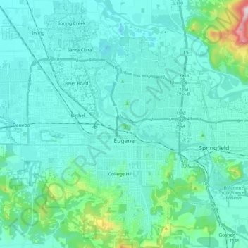
Name: Topografische Karte Eugene, Höhe, Relief.
Ort: Eugene, Lane County, Oregon, United States (43.98753 -123.20876 44.13227 -123.03059)
Durchschnittliche Höhe: 163 m
Minimale Höhe: 88 m
Maximale Höhe: 689 m
According to the United States Census Bureau, the city has a total area of 43.74 square miles (113.29 km2), of which 43.72 square miles (113.23 km2) is land and 0.02 square miles (0.05 km2) is water. Eugene is at an elevation of 426 feet (130 m).
Andere topografische Karten
Klicken Sie auf eine Karte, um ihre Topografie, ihre Höhe und ihr Relief anzuzeigen.
Rainbow
United States > Oregon > Lane County > Rainbow
Rainbow, Lane County, Oregon, 97413, United States
Durchschnittliche Höhe: 486 m
Fuji Mountain
United States > Oregon > Lane County
Fuji Mountain, Lane County, Oregon, United States
Durchschnittliche Höhe: 1.885 m
Oakridge
United States > Oregon > Lane County
Oakridge, Lane County, Oregon, 97463, United States
Durchschnittliche Höhe: 465 m
Springfield
United States > Oregon > Lane County > Springfield
Springfield, Lane County, Oregon, United States
Durchschnittliche Höhe: 177 m
Florence
United States > Oregon > Lane County
Florence, Lane County, Oregon, United States
Durchschnittliche Höhe: 22 m
Creswell
United States > Oregon > Lane County
Creswell, Lane County, Oregon, 97426, United States
Durchschnittliche Höhe: 165 m