
Topografische Karte Oakridge
Interaktive Karte
Klicken Sie auf die Karte, um die Höhe anzuzeigen.
Über diese Karte
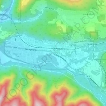
Name: Topografische Karte Oakridge, Höhe, Relief.
Ort: Oakridge, Lane County, Oregon, 97463, United States (43.73131 -122.49623 43.75831 -122.43861)
Durchschnittliche Höhe: 465 m
Minimale Höhe: 323 m
Maximale Höhe: 848 m
The city was originally a community called "Hazeldell", and its post office was established on July 26, 1888. When a station on the Southern Pacific Railroad opened in May 1912, it was named "Oak Ridge" by a railroad executive for the surrounding topography, and on July 19 of that year the name was changed to be spelled as a single word.
Andere topografische Karten
Klicken Sie auf eine Karte, um ihre Topografie, ihre Höhe und ihr Relief anzuzeigen.
Rainbow
United States > Oregon > Lane County > Rainbow
Rainbow, Lane County, Oregon, 97413, United States
Durchschnittliche Höhe: 486 m
Fuji Mountain
United States > Oregon > Lane County
Fuji Mountain, Lane County, Oregon, United States
Durchschnittliche Höhe: 1.885 m
Eugene
United States > Oregon > Lane County
Eugene, Lane County, Oregon, United States
Durchschnittliche Höhe: 163 m
Springfield
United States > Oregon > Lane County > Springfield
Springfield, Lane County, Oregon, United States
Durchschnittliche Höhe: 177 m
Florence
United States > Oregon > Lane County
Florence, Lane County, Oregon, United States
Durchschnittliche Höhe: 22 m
Creswell
United States > Oregon > Lane County
Creswell, Lane County, Oregon, 97426, United States
Durchschnittliche Höhe: 165 m