
Vielen Dank für die Unterstützung dieser Website ❤️
Spenden
Spenden
Rüsten Sie sich für Ihr nächstes Abenteuer:
Als Amazon-Partner verdient diese Website an qualifizierten Käufen, ohne dass Ihnen zusätzliche Kosten entstehen.
Topografische Karte Estany Gran d'Amitges
Klicken Sie auf die Karte, um die Höhe anzuzeigen.
Vielen Dank für die Unterstützung dieser Website ❤️
Spenden
Spenden
Rüsten Sie sich für Ihr nächstes Abenteuer:
Als Amazon-Partner verdient diese Website an qualifizierten Käufen, ohne dass Ihnen zusätzliche Kosten entstehen.
Über diese Karte
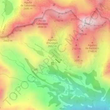
Name: Topografische Karte Estany Gran d'Amitges, Höhe, Relief.
Ort: Estany Gran d'Amitges, Espot, Pallars Sobirá, Cataluña, España (42.59696 0.98254 42.60053 0.98739)
Durchschnittliche Höhe: 2.452 m
Minimale Höhe: 1.979 m
Maximale Höhe: 2.890 m
Vielen Dank für die Unterstützung dieser Website ❤️
Spenden
Spenden
Rüsten Sie sich für Ihr nächstes Abenteuer:
Als Amazon-Partner verdient diese Website an qualifizierten Käufen, ohne dass Ihnen zusätzliche Kosten entstehen.
Andere topografische Karten
Klicken Sie auf eine Karte, um ihre Topografie, ihre Höhe und ihr Relief anzuzeigen.