
Spenden
Rüsten Sie sich für Ihr nächstes Abenteuer:
Als Amazon-Partner verdient diese Website an qualifizierten Käufen, ohne dass Ihnen zusätzliche Kosten entstehen.
Topografische Karte Pic de la Mainera
Klicken Sie auf die Karte, um die Höhe anzuzeigen.
Spenden
Rüsten Sie sich für Ihr nächstes Abenteuer:
Als Amazon-Partner verdient diese Website an qualifizierten Käufen, ohne dass Ihnen zusätzliche Kosten entstehen.
Über diese Karte
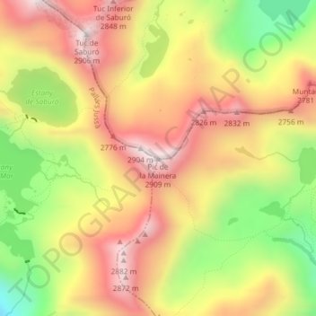
Name: Topografische Karte Pic de la Mainera, Höhe, Relief.
Ort: Pic de la Mainera, Espot, Pallars Sobirá, Cataluña, España (42.52443 1.02712 42.52453 1.02722)
Durchschnittliche Höhe: 2.576 m
Minimale Höhe: 2.187 m
Maximale Höhe: 2.887 m
Spenden
Rüsten Sie sich für Ihr nächstes Abenteuer:
Als Amazon-Partner verdient diese Website an qualifizierten Käufen, ohne dass Ihnen zusätzliche Kosten entstehen.
Andere topografische Karten
Klicken Sie auf eine Karte, um ihre Topografie, ihre Höhe und ihr Relief anzuzeigen.
Estany de Sant Maurici
España > Cataluña > Pallars Sobirá > Espot
Está situado a 1910 m de altitud, en el fondo de un circo glaciar. Recibe las aguas de los ríos y torrentes de Ratera, del Portarró y Subenuix, mientras que su emisario, el río Escrita, drena el valle de Espot hasta el Noguera Pallaresa. Se encuentra dentro de un circo de origen glaciar en la región…
Durchschnittliche Höhe: 2.179 m