
Topografische Karte Chao
Interaktive Karte
Klicken Sie auf die Karte, um die Höhe anzuzeigen.
Über diese Karte
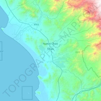
Name: Topografische Karte Chao, Höhe, Relief.
Ort: Chao, Province of Virú, La Libertad, Peru (-8.77502 -78.75562 -8.32126 -78.23558)
Durchschnittliche Höhe: 428 m
Minimale Höhe: -2 m
Maximale Höhe: 3.845 m
Andere topografische Karten
Klicken Sie auf eine Karte, um ihre Topografie, ihre Höhe und ihr Relief anzuzeigen.
Carabamba
Carabamba, Province of Julcán, La Libertad, Peru
Durchschnittliche Höhe: 2.844 m
El Paraíso
Peru > La Libertad > Rázuri
El Paraíso, Rázuri, Province of Ascope, La Libertad, Peru
Durchschnittliche Höhe: 22 m
Abdon
Peru > La Libertad > Longotea
Abdon, Longotea, Province of Bolívar, La Libertad, Peru
Durchschnittliche Höhe: 2.919 m
Magdalena de Cao
Magdalena de Cao, Province of Ascope, La Libertad, Peru
Durchschnittliche Höhe: 34 m
Curva de Sun
Peru > La Libertad > Curva de Sun
Curva de Sun, Moche, Province of Trujillo, La Libertad, 13600, Peru
Durchschnittliche Höhe: 16 m
Huamachuco
Peru > La Libertad > Huamachuco
Huamachuco, Province of Sánchez Carrión, La Libertad, Peru
Durchschnittliche Höhe: 3.359 m
Province of Virú
Province of Virú, La Libertad, Peru
Durchschnittliche Höhe: 1.120 m
Jequetepeque
Peru > La Libertad > Jequetepeque
Jequetepeque, Province of Pacasmayo, La Libertad, Peru
Durchschnittliche Höhe: 27 m
Province of Virú
Peru > La Libertad > Chao
Province of Virú, Chao, Virú, La Libertad, Peru
Durchschnittliche Höhe: 606 m
Mollepata
Peru > La Libertad > Mollepata
Mollepata, Santiago de Chuco, La Libertad, Peru
Durchschnittliche Höhe: 3.324 m