
Topografische Karte Montfoort
Interaktive Karte
Klicken Sie auf die Karte, um die Höhe anzuzeigen.
Über diese Karte
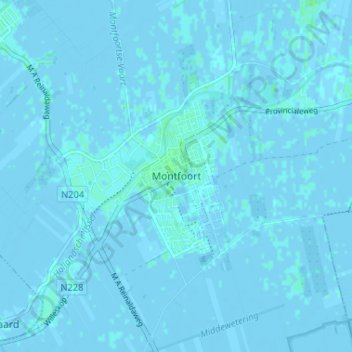
Name: Topografische Karte Montfoort, Höhe, Relief.
Ort: Montfoort, Utrecht, Nederland, 3417, Nederland (52.02419 4.93140 52.06419 4.97140)
Durchschnittliche Höhe: 0 m
Minimale Höhe: -3 m
Maximale Höhe: 4 m
Andere topografische Karten
Klicken Sie auf eine Karte, um ihre Topografie, ihre Höhe und ihr Relief anzuzeigen.
Huis Te Linschoten
Nederland > Utrecht > Montfoort
Huis Te Linschoten, Montfoort, Utrecht, Nederland, 3461AC, Nederland
Durchschnittliche Höhe: 0 m