Geolokalisieren

Topografische Karte San Antolín de Ibias

Interaktive Karte

Klicken Sie auf die Karte, um die Höhe anzuzeigen.

Über diese Karte

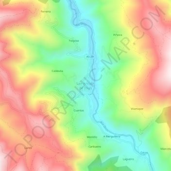
Name: Topografische Karte San Antolín de Ibias, Höhe, Relief.

Ort: San Antolín de Ibias, Ibias, Asturias, España (43.01863 -6.89239 43.05863 -6.85239)

Durchschnittliche Höhe: 550 m

Minimale Höhe: 245 m

Maximale Höhe: 884 m

Andere topografische Karten

Klicken Sie auf eine Karte, um ihre Topografie, ihre Höhe und ihr Relief anzuzeigen.

Peneda

España > Asturias > Ibias

Peneda, Ibias, Asturias, 33810, España

Durchschnittliche Höhe: 651 m

Ibias

España > Asturias > Ibias

Ibias, Asturias, 33810, España

Durchschnittliche Höhe: 914 m

Forna

España > Asturias > Ibias > Forna

Forna, Ibias, Asturias, España

Durchschnittliche Höhe: 570 m

Ricabo

España > Asturias > Ibias

Ricabo, Ibias, Asturias, España

Durchschnittliche Höhe: 476 m

Cecos

España > Asturias > Ibias

Cecos, Ibias, Asturias, España

Durchschnittliche Höhe: 587 m