
Topografische Karte Ricabo
Interaktive Karte
Klicken Sie auf die Karte, um die Höhe anzuzeigen.
Über diese Karte
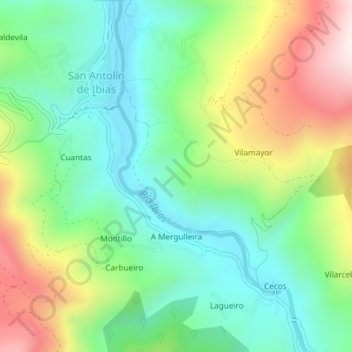
Name: Topografische Karte Ricabo, Höhe, Relief.
Ort: Ricabo, Ibias, Asturias, España (43.02142 -6.87397 43.04142 -6.85397)
Durchschnittliche Höhe: 476 m
Minimale Höhe: 258 m
Maximale Höhe: 874 m
Andere topografische Karten
Klicken Sie auf eine Karte, um ihre Topografie, ihre Höhe und ihr Relief anzuzeigen.
San Antolín de Ibias
San Antolín de Ibias, Ibias, Asturias, España
Durchschnittliche Höhe: 550 m