
Topografische Karte Oxford Mills
Interaktive Karte
Klicken Sie auf die Karte, um die Höhe anzuzeigen.
Über diese Karte
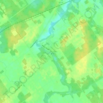
Name: Topografische Karte Oxford Mills, Höhe, Relief.
Durchschnittliche Höhe: 103 m
Minimale Höhe: 91 m
Maximale Höhe: 111 m
Andere topografische Karten
Klicken Sie auf eine Karte, um ihre Topografie, ihre Höhe und ihr Relief anzuzeigen.
Kemptville
Canada > Ontario > Leeds and Grenville Counties > North Grenville
Kemptville, North Grenville, Leeds and Grenville Counties, Eastern Ontario, Ontario, K0G 1J0, Canada
Durchschnittliche Höhe: 97 m
North Grenville
Canada > Ontario > Leeds and Grenville Counties > North Grenville
North Grenville, Leeds and Grenville Counties, Eastern Ontario, Ontario, Canada
Durchschnittliche Höhe: 98 m