
Spenden
Rüsten Sie sich für Ihr nächstes Abenteuer:
Als Amazon-Partner verdient diese Website an qualifizierten Käufen, ohne dass Ihnen zusätzliche Kosten entstehen.
Topografische Karte North Grenville
Klicken Sie auf die Karte, um die Höhe anzuzeigen.
Spenden
Rüsten Sie sich für Ihr nächstes Abenteuer:
Als Amazon-Partner verdient diese Website an qualifizierten Käufen, ohne dass Ihnen zusätzliche Kosten entstehen.
Über diese Karte
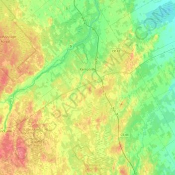
Name: Topografische Karte North Grenville, Höhe, Relief.
Durchschnittliche Höhe: 98 m
Minimale Höhe: 74 m
Maximale Höhe: 133 m
Spenden
Rüsten Sie sich für Ihr nächstes Abenteuer:
Als Amazon-Partner verdient diese Website an qualifizierten Käufen, ohne dass Ihnen zusätzliche Kosten entstehen.
Andere topografische Karten
Klicken Sie auf eine Karte, um ihre Topografie, ihre Höhe und ihr Relief anzuzeigen.
Kemptville
Canada > Ontario > Leeds and Grenville Counties > North Grenville
Durchschnittliche Höhe: 97 m
Spenden
Rüsten Sie sich für Ihr nächstes Abenteuer:
Als Amazon-Partner verdient diese Website an qualifizierten Käufen, ohne dass Ihnen zusätzliche Kosten entstehen.
Mallorytown Landing
Canada > Ontario > Leeds and Grenville Counties > Front of Yonge
Durchschnittliche Höhe: 86 m
Groveton
Canada > Ontario > Leeds and Grenville Counties > Edwardsburgh/Cardinal
Durchschnittliche Höhe: 99 m
Spenden
Rüsten Sie sich für Ihr nächstes Abenteuer:
Als Amazon-Partner verdient diese Website an qualifizierten Käufen, ohne dass Ihnen zusätzliche Kosten entstehen.
Lyn
Canada > Ontario > Leeds and Grenville Counties > Elizabethtown-Kitley
Durchschnittliche Höhe: 102 m
Seeleys Bay
Canada > Ontario > Leeds and Grenville Counties > Leeds and the Thousand Islands > Seeley's Bay
Durchschnittliche Höhe: 105 m
Little Crosby Lake
Canada > Ontario > Leeds and Grenville Counties > Rideau Lakes
Durchschnittliche Höhe: 166 m
Spenden
Rüsten Sie sich für Ihr nächstes Abenteuer:
Als Amazon-Partner verdient diese Website an qualifizierten Käufen, ohne dass Ihnen zusätzliche Kosten entstehen.
Johnstown
Canada > Ontario > Leeds and Grenville Counties > Edwardsburgh/Cardinal
Durchschnittliche Höhe: 83 m
Lansdowne
Canada > Ontario > Leeds and Grenville Counties > Leeds and the Thousand Islands
Durchschnittliche Höhe: 101 m
Harvey Island
Canada > Ontario > Leeds and Grenville Counties > Elizabethtown-Kitley
Durchschnittliche Höhe: 111 m
Spenden
Rüsten Sie sich für Ihr nächstes Abenteuer:
Als Amazon-Partner verdient diese Website an qualifizierten Käufen, ohne dass Ihnen zusätzliche Kosten entstehen.
Philipsville
Canada > Ontario > Leeds and Grenville Counties > Rideau Lakes
Durchschnittliche Höhe: 122 m
Cardinal
Canada > Ontario > Leeds and Grenville Counties > Edwardsburgh/Cardinal
Durchschnittliche Höhe: 82 m
Tincap
Canada > Ontario > Leeds and Grenville Counties > Elizabethtown-Kitley
Durchschnittliche Höhe: 113 m
Actons Corners
Canada > Ontario > Leeds and Grenville Counties > North Grenville
Durchschnittliche Höhe: 97 m
Spenden
Rüsten Sie sich für Ihr nächstes Abenteuer:
Als Amazon-Partner verdient diese Website an qualifizierten Käufen, ohne dass Ihnen zusätzliche Kosten entstehen.
Frankville
Canada > Ontario > Leeds and Grenville Counties > Elizabethtown-Kitley
Durchschnittliche Höhe: 118 m
Merrickville
Canada > Ontario > Leeds and Grenville Counties > Merrickville-Wolford
Durchschnittliche Höhe: 114 m
Spectacle Lake
Canada > Ontario > Leeds and Grenville Counties > Rideau Lakes
Durchschnittliche Höhe: 189 m
Spenden
Rüsten Sie sich für Ihr nächstes Abenteuer:
Als Amazon-Partner verdient diese Website an qualifizierten Käufen, ohne dass Ihnen zusätzliche Kosten entstehen.
Spencerville
Canada > Ontario > Leeds and Grenville Counties > Edwardsburgh/Cardinal
Durchschnittliche Höhe: 99 m
Oxford Mills
Canada > Ontario > Leeds and Grenville Counties > North Grenville
Durchschnittliche Höhe: 103 m
Toledo
Canada > Ontario > Leeds and Grenville Counties > Elizabethtown-Kitley
Durchschnittliche Höhe: 121 m
Spenden
Rüsten Sie sich für Ihr nächstes Abenteuer:
Als Amazon-Partner verdient diese Website an qualifizierten Käufen, ohne dass Ihnen zusätzliche Kosten entstehen.
Waterton
Canada > Ontario > Leeds and Grenville Counties > Leeds and the Thousand Islands > Waterton
Durchschnittliche Höhe: 97 m
Seeley's Bay
Canada > Ontario > Leeds and Grenville Counties > Leeds and the Thousand Islands
Durchschnittliche Höhe: 106 m
Crosby
Canada > Ontario > Leeds and Grenville Counties > Rideau Lakes > Crosby
Durchschnittliche Höhe: 128 m
Greenbush
Canada > Ontario > Leeds and Grenville Counties > Elizabethtown-Kitley > Greenbush
Durchschnittliche Höhe: 120 m
Spenden
Rüsten Sie sich für Ihr nächstes Abenteuer:
Als Amazon-Partner verdient diese Website an qualifizierten Käufen, ohne dass Ihnen zusätzliche Kosten entstehen.
Motts Mills
Canada > Ontario > Leeds and Grenville Counties > Elizabethtown-Kitley
Durchschnittliche Höhe: 126 m
Codfish Island
Canada > Ontario > Leeds and Grenville Counties > Leeds and the Thousand Islands
Durchschnittliche Höhe: 79 m
Why Island
Canada > Ontario > Leeds and Grenville Counties > Leeds and the Thousand Islands
Durchschnittliche Höhe: 92 m
Spenden
Rüsten Sie sich für Ihr nächstes Abenteuer:
Als Amazon-Partner verdient diese Website an qualifizierten Käufen, ohne dass Ihnen zusätzliche Kosten entstehen.
Seeleys Bay
Canada > Ontario > Leeds and Grenville Counties > Leeds and the Thousand Islands > Seeley's Bay
Durchschnittliche Höhe: 105 m
Outlet
Canada > Ontario > Leeds and Grenville Counties > Leeds and the Thousand Islands
Durchschnittliche Höhe: 97 m
Glen Buell
Canada > Ontario > Leeds and Grenville Counties > Elizabethtown-Kitley
Durchschnittliche Höhe: 120 m
Spenden
Rüsten Sie sich für Ihr nächstes Abenteuer:
Als Amazon-Partner verdient diese Website an qualifizierten Käufen, ohne dass Ihnen zusätzliche Kosten entstehen.
Cardinal
Canada > Ontario > Leeds and Grenville Counties > Edwardsburgh/Cardinal
Durchschnittliche Höhe: 82 m