
Topografische Karte Altus
Interaktive Karte
Klicken Sie auf die Karte, um die Höhe anzuzeigen.
Über diese Karte
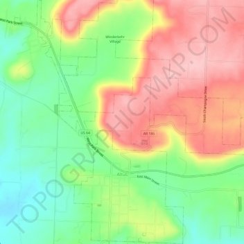
Name: Topografische Karte Altus, Höhe, Relief.
Ort: Altus, Franklin County, Arkansas, 72821, United States (35.43244 -93.78921 35.48086 -93.74796)
Durchschnittliche Höhe: 192 m
Minimale Höhe: 112 m
Maximale Höhe: 278 m
Altus had its start in 1875 when the railroad was extended to that point. Altus station was the highest point on the track. In recognition of this highest railroad elevation between Little Rock and Fort Smith, the station was originally known as "Summit". The town's initial development was due to railroad efforts encouraging German immigration to settle lands adjacent to the railroad. In 1903, the railroad mainline was shifted to a more favorable alignment along the Arkansas River. The track through Altus was removed in the 1930s, but the railroad station has been preserved as a commercial establishment.
Andere topografische Karten
Klicken Sie auf eine Karte, um ihre Topografie, ihre Höhe und ihr Relief anzuzeigen.
Charleston
United States > Arkansas > Franklin County
Charleston, Franklin County, Arkansas, United States
Durchschnittliche Höhe: 156 m
Webb City
United States > Arkansas > Franklin County
Webb City, Franklin County, Arkansas, 72949, United States
Durchschnittliche Höhe: 135 m
Vesta
United States > Arkansas > Franklin County
Vesta, Franklin County, Arkansas, United States
Durchschnittliche Höhe: 147 m
Cecil
United States > Arkansas > Franklin County
Cecil, Franklin County, Arkansas, 72930, United States
Durchschnittliche Höhe: 233 m
Branch
United States > Arkansas > Franklin County
Branch, Franklin County, Arkansas, 72928, United States
Durchschnittliche Höhe: 148 m
Peanut
United States > Arkansas > Franklin County
Peanut, Franklin County, Arkansas, United States
Durchschnittliche Höhe: 372 m
Alix
United States > Arkansas > Franklin County
Alix, Franklin County, Arkansas, 72820, United States
Durchschnittliche Höhe: 129 m
Denning
United States > Arkansas > Franklin County
Denning, Franklin County, Arkansas, 72821, United States
Durchschnittliche Höhe: 139 m
Wiederkehr Village
United States > Arkansas > Franklin County
Wiederkehr Village, Franklin County, Arkansas, United States
Durchschnittliche Höhe: 209 m
Ozark
United States > Arkansas > Franklin County
Ozark, Franklin County, Arkansas, 72949, United States
Durchschnittliche Höhe: 167 m
Redding
United States > Arkansas > Franklin County > Redding
Redding, Franklin County, Arkansas, United States
Durchschnittliche Höhe: 308 m