
Topografische Karte Webb City
Interaktive Karte
Klicken Sie auf die Karte, um die Höhe anzuzeigen.
Über diese Karte
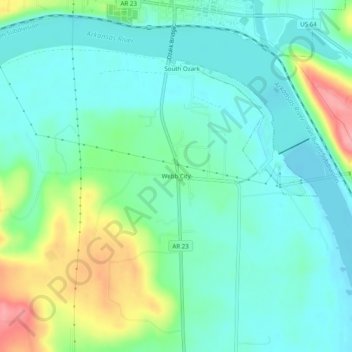
Name: Topografische Karte Webb City, Höhe, Relief.
Ort: Webb City, Franklin County, Arkansas, 72949, United States (35.44814 -93.85186 35.48814 -93.81186)
Durchschnittliche Höhe: 135 m
Minimale Höhe: 106 m
Maximale Höhe: 213 m
Andere topografische Karten
Klicken Sie auf eine Karte, um ihre Topografie, ihre Höhe und ihr Relief anzuzeigen.
Charleston
United States > Arkansas > Franklin County
Charleston, Franklin County, Arkansas, United States
Durchschnittliche Höhe: 156 m
Vesta
United States > Arkansas > Franklin County
Vesta, Franklin County, Arkansas, United States
Durchschnittliche Höhe: 147 m
Cecil
United States > Arkansas > Franklin County
Cecil, Franklin County, Arkansas, 72930, United States
Durchschnittliche Höhe: 233 m
Branch
United States > Arkansas > Franklin County
Branch, Franklin County, Arkansas, 72928, United States
Durchschnittliche Höhe: 148 m
Peanut
United States > Arkansas > Franklin County
Peanut, Franklin County, Arkansas, United States
Durchschnittliche Höhe: 372 m
Alix
United States > Arkansas > Franklin County
Alix, Franklin County, Arkansas, 72820, United States
Durchschnittliche Höhe: 129 m
Denning
United States > Arkansas > Franklin County
Denning, Franklin County, Arkansas, 72821, United States
Durchschnittliche Höhe: 139 m
Wiederkehr Village
United States > Arkansas > Franklin County
Wiederkehr Village, Franklin County, Arkansas, United States
Durchschnittliche Höhe: 209 m
Altus
United States > Arkansas > Franklin County
Altus, Franklin County, Arkansas, 72821, United States
Durchschnittliche Höhe: 192 m
Ozark
United States > Arkansas > Franklin County
Ozark, Franklin County, Arkansas, 72949, United States
Durchschnittliche Höhe: 167 m
Redding
United States > Arkansas > Franklin County > Redding
Redding, Franklin County, Arkansas, United States
Durchschnittliche Höhe: 308 m