
Topografische Karte Richmond Hill
Interaktive Karte
Klicken Sie auf die Karte, um die Höhe anzuzeigen.
Über diese Karte
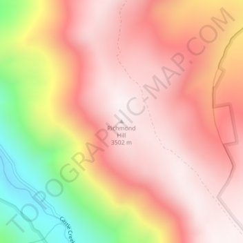
Name: Topografische Karte Richmond Hill, Höhe, Relief.
Ort: Richmond Hill, Pitkin County, Colorado, United States (39.10577 -106.81009 39.10587 -106.80999)
Durchschnittliche Höhe: 3.237 m
Minimale Höhe: 2.713 m
Maximale Höhe: 3.505 m
Andere topografische Karten
Klicken Sie auf eine Karte, um ihre Topografie, ihre Höhe und ihr Relief anzuzeigen.
Aspen
United States > Colorado > Pitkin County
Aspen, Pitkin County, Colorado, United States
Durchschnittliche Höhe: 2.568 m
Snowmass Village
United States > Colorado > Pitkin County
Snowmass Village, Pitkin County, Colorado, 81615, United States
Durchschnittliche Höhe: 2.675 m
Castle Peak
United States > Colorado > Pitkin County
Castle Peak, Pitkin County, Colorado, United States
Durchschnittliche Höhe: 3.910 m
Maroon Bells
United States > Colorado > Pitkin County
Maroon Bells, Pitkin County, Colorado, United States
Durchschnittliche Höhe: 3.691 m
Snowmass
United States > Colorado > Pitkin County
Snowmass, Pitkin County, Colorado, 81654, United States
Durchschnittliche Höhe: 2.322 m