
Topografische Karte Maroon Bells
Interaktive Karte
Klicken Sie auf die Karte, um die Höhe anzuzeigen.
Über diese Karte
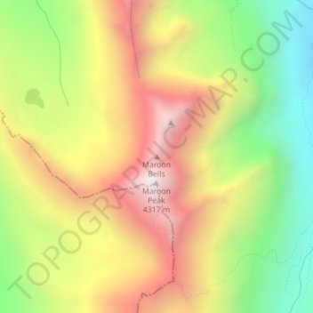
Name: Topografische Karte Maroon Bells, Höhe, Relief.
Ort: Maroon Bells, Pitkin County, Colorado, United States (39.07303 -106.98873 39.07313 -106.98863)
Durchschnittliche Höhe: 3.691 m
Minimale Höhe: 3.084 m
Maximale Höhe: 4.309 m
Maroon Lake, elevation 2,920 m (9,580 ft), occupies a basin that was sculpted by Ice Age glaciers and later dammed by a landslide and rockfall debris from the steep slopes above the valley floor.
Andere topografische Karten
Klicken Sie auf eine Karte, um ihre Topografie, ihre Höhe und ihr Relief anzuzeigen.
Aspen
United States > Colorado > Pitkin County
Aspen, Pitkin County, Colorado, United States
Durchschnittliche Höhe: 2.568 m
Snowmass Village
United States > Colorado > Pitkin County
Snowmass Village, Pitkin County, Colorado, 81615, United States
Durchschnittliche Höhe: 2.675 m
Castle Peak
United States > Colorado > Pitkin County
Castle Peak, Pitkin County, Colorado, United States
Durchschnittliche Höhe: 3.910 m
Richmond Hill
United States > Colorado > Pitkin County
Richmond Hill, Pitkin County, Colorado, United States
Durchschnittliche Höhe: 3.237 m
Snowmass
United States > Colorado > Pitkin County
Snowmass, Pitkin County, Colorado, 81654, United States
Durchschnittliche Höhe: 2.322 m