
Topografische Karte Howe
Interaktive Karte
Klicken Sie auf die Karte, um die Höhe anzuzeigen.
Über diese Karte
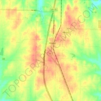
Name: Topografische Karte Howe, Höhe, Relief.
Ort: Howe, Grayson County, Texas, 75459, United States (33.46537 -96.65025 33.53849 -96.59389)
Durchschnittliche Höhe: 248 m
Minimale Höhe: 218 m
Maximale Höhe: 269 m
Howe's elevation of 860 feet (260 m) is the highest point along US 75 between the Red River and the Gulf of Mexico.
Andere topografische Karten
Klicken Sie auf eine Karte, um ihre Topografie, ihre Höhe und ihr Relief anzuzeigen.
Cannon
United States > Texas > Grayson County
Cannon, Grayson County, Texas, United States
Durchschnittliche Höhe: 221 m
Sherman
United States > Texas > Grayson County
Sherman, Grayson County, Texas, United States
Durchschnittliche Höhe: 228 m
Tom Bean
United States > Texas > Grayson County
Tom Bean, Grayson County, Texas, 75489, United States
Durchschnittliche Höhe: 237 m
Preston
United States > Texas > Grayson County
Preston, Grayson County, Texas, United States
Durchschnittliche Höhe: 193 m
Denison
United States > Texas > Grayson County
Denison, Grayson County, Texas, 75020, United States
Durchschnittliche Höhe: 199 m
Mills
United States > Texas > Grayson County > Denison
Mills, Denison, Grayson County, Texas, 75021, United States
Durchschnittliche Höhe: 208 m
Pottsboro
United States > Texas > Grayson County
Pottsboro, Grayson County, Texas, United States
Durchschnittliche Höhe: 226 m
Eisenhower State Park
United States > Texas > Grayson County > Denison
Eisenhower State Park, Denison, Grayson County, Texas, 75020, United States
Durchschnittliche Höhe: 209 m
Van Alstyne
United States > Texas > Grayson County > Van Alstyne
Van Alstyne, Grayson County, Texas, 75495, United States
Durchschnittliche Höhe: 225 m
Bells
United States > Texas > Grayson County
Bells, Grayson County, Texas, United States
Durchschnittliche Höhe: 203 m
Gunter
United States > Texas > Grayson County
Gunter, Grayson County, Texas, United States
Durchschnittliche Höhe: 226 m
Howe
United States > Texas > Grayson County > Howe
Howe, Grayson County, Texas, 75459, United States
Durchschnittliche Höhe: 248 m
Whitewright
United States > Texas > Grayson County > Whitewright
Whitewright, Grayson County, Texas, United States
Durchschnittliche Höhe: 230 m
Van Alstyne
United States > Texas > Grayson County
Van Alstyne, Grayson County, Texas, 75495, United States
Durchschnittliche Höhe: 227 m
Collinsville
United States > Texas > Grayson County > Collinsville
Collinsville, Grayson County, Texas, United States
Durchschnittliche Höhe: 221 m
Tioga
United States > Texas > Grayson County > Tioga
Tioga, Grayson County, Texas, United States
Durchschnittliche Höhe: 201 m
Bells
United States > Texas > Grayson County > Bells
Bells, Grayson County, Texas, United States
Durchschnittliche Höhe: 203 m
Penland
United States > Texas > Grayson County
Penland, Grayson County, Texas, United States
Durchschnittliche Höhe: 182 m