
Topografische Karte Bells
Interaktive Karte
Klicken Sie auf die Karte, um die Höhe anzuzeigen.
Über diese Karte
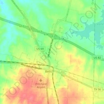
Name: Topografische Karte Bells, Höhe, Relief.
Ort: Bells, Grayson County, Texas, United States (33.59330 -96.44502 33.64820 -96.38920)
Durchschnittliche Höhe: 203 m
Minimale Höhe: 175 m
Maximale Höhe: 238 m
Andere topografische Karten
Klicken Sie auf eine Karte, um ihre Topografie, ihre Höhe und ihr Relief anzuzeigen.
Cannon
United States > Texas > Grayson County
Cannon, Grayson County, Texas, United States
Durchschnittliche Höhe: 221 m
Sherman
United States > Texas > Grayson County
Sherman, Grayson County, Texas, United States
Durchschnittliche Höhe: 228 m
Tom Bean
United States > Texas > Grayson County
Tom Bean, Grayson County, Texas, 75489, United States
Durchschnittliche Höhe: 237 m
Preston
United States > Texas > Grayson County
Preston, Grayson County, Texas, United States
Durchschnittliche Höhe: 193 m
Denison
United States > Texas > Grayson County
Denison, Grayson County, Texas, 75020, United States
Durchschnittliche Höhe: 199 m
Mills
United States > Texas > Grayson County > Denison
Mills, Denison, Grayson County, Texas, 75021, United States
Durchschnittliche Höhe: 208 m
Pottsboro
United States > Texas > Grayson County
Pottsboro, Grayson County, Texas, United States
Durchschnittliche Höhe: 226 m
Eisenhower State Park
United States > Texas > Grayson County > Denison
Eisenhower State Park, Denison, Grayson County, Texas, 75020, United States
Durchschnittliche Höhe: 209 m
Van Alstyne
United States > Texas > Grayson County > Van Alstyne
Van Alstyne, Grayson County, Texas, 75495, United States
Durchschnittliche Höhe: 225 m
Gunter
United States > Texas > Grayson County
Gunter, Grayson County, Texas, United States
Durchschnittliche Höhe: 226 m
Howe
United States > Texas > Grayson County
Howe, Grayson County, Texas, 75459, United States
Durchschnittliche Höhe: 248 m
Howe
United States > Texas > Grayson County > Howe
Howe, Grayson County, Texas, 75459, United States
Durchschnittliche Höhe: 248 m
Whitewright
United States > Texas > Grayson County > Whitewright
Whitewright, Grayson County, Texas, United States
Durchschnittliche Höhe: 230 m
Van Alstyne
United States > Texas > Grayson County
Van Alstyne, Grayson County, Texas, 75495, United States
Durchschnittliche Höhe: 227 m
Collinsville
United States > Texas > Grayson County > Collinsville
Collinsville, Grayson County, Texas, United States
Durchschnittliche Höhe: 221 m
Tioga
United States > Texas > Grayson County > Tioga
Tioga, Grayson County, Texas, United States
Durchschnittliche Höhe: 201 m
Bells
United States > Texas > Grayson County > Bells
Bells, Grayson County, Texas, United States
Durchschnittliche Höhe: 203 m
Penland
United States > Texas > Grayson County
Penland, Grayson County, Texas, United States
Durchschnittliche Höhe: 182 m