
Topografische Karte Penedono
Interaktive Karte
Klicken Sie auf die Karte, um die Höhe anzuzeigen.
Über diese Karte
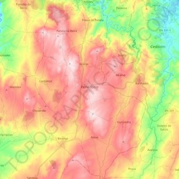
Name: Topografische Karte Penedono, Höhe, Relief.
Ort: Penedono, Viseu, Portugal (40.90452 -7.46146 41.07013 -7.32527)
Durchschnittliche Höhe: 738 m
Minimale Höhe: 435 m
Maximale Höhe: 996 m
Erguendo-se a mais de 900 metros de altitude, o medievo Castelo de Penedono pentagonal, classificado como Monumento Nacional, data de cerca de 900.
Andere topografische Karten
Klicken Sie auf eine Karte, um ihre Topografie, ihre Höhe und ihr Relief anzuzeigen.
Paranho de Besteiros
Paranho de Besteiros, Caparrosa e Silvares, Tondela, Viseu, 3460-454, Portugal
Durchschnittliche Höhe: 458 m
Sobral
Portugal > Viseu > São Pedro do Sul > Pinho
Sobral, Pinho, São Pedro do Sul, Viseu, Portugal
Durchschnittliche Höhe: 392 m
Rio de Mel
Portugal > Viseu > São Pedro do Sul > Pindelo dos Milagres
Rio de Mel, Pindelo dos Milagres, São Pedro do Sul, Viseu, Portugal
Durchschnittliche Höhe: 405 m
Lages de Ranhados
Portugal > Viseu > Viseu > Ranhados
Lages de Ranhados, Ranhados, Viseu, 3500-456, Portugal
Durchschnittliche Höhe: 455 m
Caselho
Portugal > Viseu > Oliveira de Frades
Caselho, Destriz e Reigoso, Oliveira de Frades, Viseu, 3750-561, Portugal
Durchschnittliche Höhe: 346 m
Canas de Senhorim
Canas de Senhorim, Nelas, Viseu, Portugal
Durchschnittliche Höhe: 342 m
Ermida
Portugal > Viseu > Castro Daire
Ermida, Picão e Ermida, Castro Daire, Viseu, Portugal
Durchschnittliche Höhe: 554 m
Mezio
Portugal > Viseu > Castro Daire
Mezio, Castro Daire, Viseu, Portugal
Durchschnittliche Höhe: 969 m
Cêtos
Portugal > Viseu > Castro Daire > Pinheiro
Cêtos, Pinheiro, Castro Daire, Viseu, Portugal
Durchschnittliche Höhe: 737 m
Macieira
Portugal > Viseu > Ferreirim e Macieira
Macieira, Ferreirim e Macieira, Sernancelhe, Viseu, 3640-110, Portugal
Durchschnittliche Höhe: 792 m
Beijós
Portugal > Viseu > Carregal do Sal
Beijós, Carregal do Sal, Viseu, Portugal
Durchschnittliche Höhe: 290 m
Mesquitela
Mesquitela, Mangualde, Viseu, 3530-051, Portugal
Durchschnittliche Höhe: 484 m
Barragem da Ribeira do Paul
Barragem da Ribeira do Paul, Vilar de Besteiros e Mosteiro de Fráguas, Tondela, Viseu, Portugal
Durchschnittliche Höhe: 362 m
Monteiras
Portugal > Viseu > Castro Daire
Monteiras, Castro Daire, Viseu, Portugal
Durchschnittliche Höhe: 898 m
Lamas
Portugal > Viseu > Sátão > Ferreira de Aves
Lamas, Ferreira de Aves, Sátão, Viseu, 3560-020, Portugal
Durchschnittliche Höhe: 643 m
Germil
Portugal > Viseu > Penalva do Castelo
Germil, Penalva do Castelo, Viseu, Portugal
Durchschnittliche Höhe: 452 m
São Pedro do Sul
Portugal > Viseu > São Pedro do Sul, Várzea e Baiões
São Pedro do Sul, São Pedro do Sul, Várzea e Baiões, São Pedro do Sul, Viseu, 3660-441, Portugal
Durchschnittliche Höhe: 324 m
Pimeirol
Portugal > Viseu > Felgueiras e Feirão > Felgueiras
Pimeirol, Felgueiras, Felgueiras e Feirão, Resende, Viseu, 4660-362, Portugal
Durchschnittliche Höhe: 703 m
Moure de Madalena
Portugal > Viseu > Viseu > Campo
Moure de Madalena, Campo, Viseu, 3515-160, Portugal
Durchschnittliche Höhe: 527 m
Louredo
Portugal > Viseu > Freigil e Miomães > Miomães
Louredo, Miomães, Freigil e Miomães, Resende, Viseu, 4640-270, Portugal
Durchschnittliche Höhe: 254 m
Mosteirinho
Mosteirinho, Tondela, Viseu, 3475-060, Portugal
Durchschnittliche Höhe: 588 m
Covelinho
Portugal > Viseu > Oliveira de Frades
Covelinho, São João da Serra, Oliveira de Frades, São João da Serra, Viseu, 3730-018, Portugal
Durchschnittliche Höhe: 431 m
Pindêlo
Portugal > Viseu > Nespereira
Pindêlo, Nespereira, Cinfães, Viseu, Portugal
Durchschnittliche Höhe: 542 m
Folgosa
Portugal > Viseu > Castro Daire
Folgosa, Castro Daire, Viseu, 3600-143, Portugal
Durchschnittliche Höhe: 596 m
Gosende
Portugal > Viseu > Castro Daire
Gosende, Castro Daire, Viseu, Portugal
Durchschnittliche Höhe: 1.011 m