
Topografische Karte Great Rift Valley
Interaktive Karte
Klicken Sie auf die Karte, um die Höhe anzuzeigen.
Über diese Karte
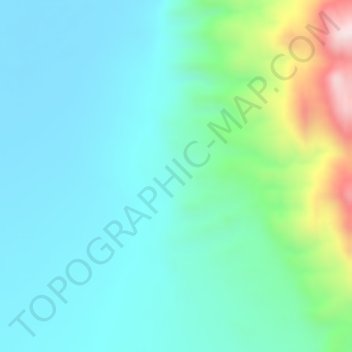
Name: Topografische Karte Great Rift Valley, Höhe, Relief.
Ort: Great Rift Valley, Borena, Oromia Region, Ethiopia (4.99995 36.99995 5.00005 37.00005)
Durchschnittliche Höhe: 631 m
Minimale Höhe: 516 m
Maximale Höhe: 1.008 m
Andere topografische Karten
Klicken Sie auf eine Karte, um ihre Topografie, ihre Höhe und ihr Relief anzuzeigen.
Dera
Dera, East Shewa, Oromia Region, Ethiopia
Durchschnittliche Höhe: 1.349 m
Burayu
Ethiopia > Oromia Region > Walmara
Burayu, Walmara, West Shewa, Oromia Region, Ethiopia
Durchschnittliche Höhe: 2.574 m
Adama
Ethiopia > Oromia Region > Adama
Adama, East Shewa, Oromia Region, 36, Ethiopia
Durchschnittliche Höhe: 1.673 m
Seka
Ethiopia > Oromia Region > Seka
Seka, Jimma, Oromia Region, Ethiopia
Durchschnittliche Höhe: 1.827 m
Bitata
Ethiopia > Oromia Region > Bitata
Bitata, Borena, Oromia Region, Ethiopia
Durchschnittliche Höhe: 1.483 m
Nekemte
Ethiopia > Oromia Region > Nekemte
Nekemte, Oromia Region, Ethiopia
Durchschnittliche Höhe: 1.910 m
Ahmar Mountains
Ahmar Mountains, West Harerghe, Oromia Region, Ethiopia
Durchschnittliche Höhe: 1.777 m
Metahara
Metahara, East Shewa, Oromia Region, Ethiopia
Durchschnittliche Höhe: 970 m
Rira
Ethiopia > Oromia Region > Rira
Rira, Bale, Oromia Region, Ethiopia
Durchschnittliche Höhe: 3.172 m