
Topografische Karte Orcas
Interaktive Karte
Klicken Sie auf die Karte, um die Höhe anzuzeigen.
Über diese Karte
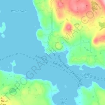
Name: Topografische Karte Orcas, Höhe, Relief.
Ort: Orcas, San Juan County, Washington, 98280, United States (48.57796 -122.96466 48.61796 -122.92466)
Durchschnittliche Höhe: 39 m
Minimale Höhe: -1 m
Maximale Höhe: 181 m
Andere topografische Karten
Klicken Sie auf eine Karte, um ihre Topografie, ihre Höhe und ihr Relief anzuzeigen.
San Juan Island
United States > Washington > San Juan County > Friday Harbor
San Juan Island, Friday Harbor, San Juan County, Washington, 98250, United States
Durchschnittliche Höhe: 26 m
Lopez Island
United States > Washington > San Juan County > Lopez Village
Lopez Island, Lopez Village, San Juan County, Washington, 98261, United States
Durchschnittliche Höhe: 21 m
Orcas Island
United States > Washington > San Juan County > Eastsound
Orcas Island, Eastsound, San Juan County, Washington, United States
Durchschnittliche Höhe: 59 m
Mount Dallas
United States > Washington > San Juan County
Mount Dallas, San Juan County, Washington, United States
Durchschnittliche Höhe: 134 m
Goose Island
United States > Washington > San Juan County
Goose Island, San Juan County, Washington, United States
Durchschnittliche Höhe: 6 m
Blakely Island
United States > Washington > San Juan County
Blakely Island, San Juan County, Washington, 98222, United States
Durchschnittliche Höhe: 60 m
Decatur Island
United States > Washington > San Juan County
Decatur Island, San Juan County, Washington, United States
Durchschnittliche Höhe: 22 m
Friday Harbor
United States > Washington > San Juan County
Friday Harbor, San Juan County, Washington, 98250, United States
Durchschnittliche Höhe: 28 m
Shaw Island
United States > Washington > San Juan County
Shaw Island, San Juan County, Washington, 98286, United States
Durchschnittliche Höhe: 23 m
Eastsound
United States > Washington > San Juan County
Eastsound, San Juan County, Washington, 98245, United States
Durchschnittliche Höhe: 74 m