
Topografische Karte Unokoti
Interaktive Karte
Klicken Sie auf die Karte, um die Höhe anzuzeigen.
Über diese Karte
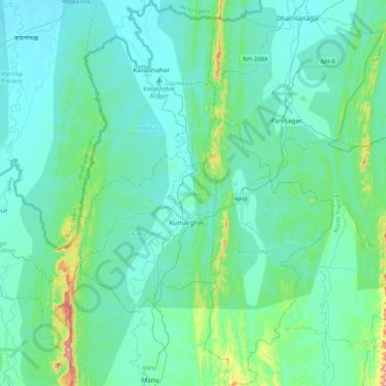
Name: Topografische Karte Unokoti, Höhe, Relief.
Ort: Unokoti, Tripura, India (23.99051 91.90787 24.39156 92.20439)
Durchschnittliche Höhe: 70 m
Minimale Höhe: 17 m
Maximale Höhe: 430 m
The topographic features seem to have influenced the climatic condition of the Unakoti district, where the plains are hotter and humid in comparison to the hills, which have a salubrious climate. The four main seasons here are
Andere topografische Karten
Klicken Sie auf eine Karte, um ihre Topografie, ihre Höhe und ihr Relief anzuzeigen.
Haora River
Haora River, Agartala, West Tripura, Tripura, 799001, India
Durchschnittliche Höhe: 18 m
Kailashahar
India > Tripura > Gournagar > Kailashahar
Kailashahar, Gournagar, Unokoti, Tripura, 799277, India
Durchschnittliche Höhe: 33 m
South Tripura
India > Tripura > South Tripura
South Tripura, Gomati, Tripura, India
Durchschnittliche Höhe: 75 m